Khawhai geodata
Khawhai (Mizoram) is a populated place; located in India in Asia/Kolkata (GMT+5.5) time zone. With population of 2,537 people, there are 3423 cities with bigger population in this country. Compared to other cities in India, 54.1% of cities are located further ↓South; 98% of cities are located further ←West and 97.2% of cities have lower elevation than Khawhai. Note1


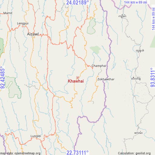
Khawhai GPS coordinates[2]
23° 22' 41.052" North, 93° 7' 40.692" East
| Map corner | latitude | longitude |
|---|---|---|
| Upper-left | 24.02189°, | 92.42485° |
| Center: | 23.37807°, | 93.12797° |
| Lower-right: | 22.73111°, | 93.8311° |
| Map W x H: | 143.5×143.5 km | = 89.2×89.2mi |
| max Lat: | 34.9274° ⇑45.9% North |
| Khawhai: | 23.37807° |
| min Lat: | ⇓54.1% South 8.09008° |
| min Long | Khawhai | max Long |
| 68.82655° | 93.12797° | 96.81° |
| W 98%⇐ | ⇒2% E |
Elevation
Elevation of Khawhai is 1335 m = 4380 ft, and this is 1039.4 m = 3410 ft above average elevation for this country.
| Max E: |
3681 m = 12077 ft | 2.8% |
| Khawhai | 1335 m 4380 ft | |
| Avg. | 295.6 m = 970 ft | |
Min E: |
1 m = 3 ft | 97.2% |
See also: India elevation on elevation.city.
Geographical zone
Khawhai is located in North Torrid zone (between Equator and Tropic of Cancer). Distance of this Northern Tropic circle is 6.5 km =4 mi to North.| Distance of | km | miles | from Khawhai |
|---|---|---|---|
| North Pole | 7407.7 | 4602.9 | to North |
| Arctic Circle | 4801.8 | 2983.7 | to North |
| Tropic Cancer | 6.5 | 4 | to North |
| Equator | 2599.4 | 1615.2 | to South |


Nearby cities:
15 places around Khawhai: (largest is in red/bold)
• Aizawl
57.2 km =35.5 mi,  313°
313°
• Chandel
138.3 km =85.9 mi,  40°
40°
• Churāchāndpur
119.7 km =74.4 mi,  27°
27°
• Darlawn
73.6 km =45.7 mi,  343°
343°
• Kolasib
104.6 km =65 mi,  334°
334°
• Lunglei
66.9 km =41.6 mi,  216°
216°
• Lāla
140.7 km =87.4 mi, 338°
• Mamit
89.2 km =55.4 mi, 313°
• North Vanlaiphai
28.1 km =17.5 mi,  193°
193°
• Pherzawl
98.5 km =61.2 mi,  3°
3°
• Saiha
99.7 km =62 mi, 188°
• Sairang
68.3 km =42.4 mi, 314°
• Serchhīp
30.2 km =18.8 mi,  251°
251°
• Sāitlaw
86.8 km =53.9 mi,  319°
319°
• Thenzawl
39.2 km =24.4 mi,  259°
259°
Sources, notices
• [Note1] Compared only with cities in India existing in our database
• [Src1] Map data: © OpenStreetMap contributors (CC-BY-SA)
• [Src2] Other city data from geonames.org with taken over terms of usage.
• [Src3] Geographical zone / Annual Mean Temperature by Robert A. Rohde @ Wikipedia
