Thenzawl geodata
Thenzawl (Mizoram) is a populated place; located in India in Asia/Kolkata (GMT+5.5) time zone. With population of 5,963 people, there are 3292 cities with bigger population in this country. Compared to other cities in India, 53.7% of cities are located further ↓South; 97.6% of cities are located further ←West and 94.4% of cities have lower elevation than Thenzawl. Note1


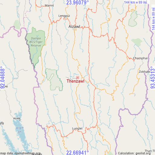
Thenzawl GPS coordinates[2]
23° 19' 0.012" North, 92° 45' 0" East
| Map corner | latitude | longitude |
|---|---|---|
| Upper-left | 23.96079°, | 92.04688° |
| Center: | 23.31667°, | 92.75° |
| Lower-right: | 22.66941°, | 93.45313° |
| Map W x H: | 143.6×143.6 km | = 89.2×89.2mi |
| max Lat: | 34.9274° ⇑46.3% North |
| Thenzawl: | 23.31667° |
| min Lat: | ⇓53.7% South 8.09008° |
| min Long | Thenzawl | max Long |
| 68.82655° | 92.75° | 96.81° |
| W 97.6%⇐ | ⇒2.4% E |
Elevation
Elevation of Thenzawl is 831 m = 2726 ft, and this is 535.4 m = 1757 ft above average elevation for this country.
| Max E: |
3681 m = 12077 ft | 5.6% |
| Thenzawl | 831 m 2726 ft | |
| Avg. | 295.6 m = 970 ft | |
Min E: |
1 m = 3 ft | 94.4% |
See also: India elevation on elevation.city.
Geographical zone
Thenzawl is located in North Torrid zone (between Equator and Tropic of Cancer). Distance of this Northern Tropic circle is 13.3 km =8.3 mi to North.| Distance of | km | miles | from Thenzawl |
|---|---|---|---|
| North Pole | 7414.5 | 4607.2 | to North |
| Arctic Circle | 4808.6 | 2987.9 | to North |
| Tropic Cancer | 13.3 | 8.3 | to North |
| Equator | 2592.6 | 1611 | to South |


Nearby cities:
15 places around Thenzawl: (largest is in red/bold)
• Aizawl
46 km =28.6 mi,  355°
355°
• Amarpur
113.7 km =70.6 mi,  281°
281°
• Darlawn
79.5 km =49.4 mi,  12°
12°
• Khawhai
39.2 km =24.4 mi,  79°
79°
• Kolasib
101.1 km =62.8 mi, 355°
• Lunglei
47.2 km =29.3 mi,  180°
180°
• Mamit
72.9 km =45.3 mi,  338°
338°
• North Vanlaiphai
38.2 km =23.7 mi,  122°
122°
• Pherzawl
114.2 km =71 mi,  23°
23°
• Sabrūm
110.6 km =68.7 mi,  251°
251°
• Saiha
94.7 km =58.8 mi,  165°
165°
• Sairang
55.8 km =34.7 mi,  349°
349°
• Serchhīp
10.2 km =6.3 mi,  104°
104°
• Sāitlaw
75 km =46.6 mi, 346°
• Āmbāsa
114.3 km =71 mi,  307°
307°
Sources, notices
• [Note1] Compared only with cities in India existing in our database
• [Src1] Map data: © OpenStreetMap contributors (CC-BY-SA)
• [Src2] Other city data from geonames.org with taken over terms of usage.
• [Src3] Geographical zone / Annual Mean Temperature by Robert A. Rohde @ Wikipedia
