Serchhīp geodata
Serchhīp (Mizoram) is a populated place; located in India in Asia/Kolkata (GMT+5.5) time zone. With population of 20,244 people, there are 2019 cities with bigger population in this country. Compared to other cities in India, 53.5% of cities are located further ↓South; 97.7% of cities are located further ←West and 96.9% of cities have lower elevation than Serchhīp. Note1


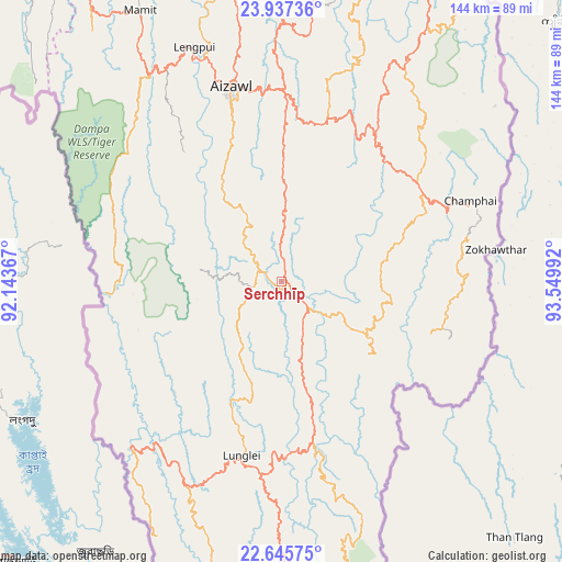
Serchhīp GPS coordinates[2]
23° 17' 35.232" North, 92° 50' 48.444" East
| Map corner | latitude | longitude |
|---|---|---|
| Upper-left | 23.93736°, | 92.14367° |
| Center: | 23.29312°, | 92.84679° |
| Lower-right: | 22.64575°, | 93.54992° |
| Map W x H: | 143.6×143.6 km | = 89.2×89.2mi |
| max Lat: | 34.9274° ⇑46.5% North |
| Serchhīp: | 23.29312° |
| min Lat: | ⇓53.5% South 8.09008° |
| min Long | Serchhīp | max Long |
| 68.82655° | 92.84679° | 96.81° |
| W 97.7%⇐ | ⇒2.3% E |
Elevation
Elevation of Serchhīp is 1231 m = 4039 ft, and this is 935.4 m = 3069 ft above average elevation for this country.
| Max E: |
3681 m = 12077 ft | 3.1% |
| Serchhīp | 1231 m 4039 ft | |
| Avg. | 295.6 m = 970 ft | |
Min E: |
1 m = 3 ft | 96.9% |
See also: India elevation on elevation.city.
Geographical zone
Serchhīp is located in North Torrid zone (between Equator and Tropic of Cancer). Distance of this Northern Tropic circle is 16 km =9.9 mi to North.| Distance of | km | miles | from Serchhīp |
|---|---|---|---|
| North Pole | 7417.1 | 4608.8 | to North |
| Arctic Circle | 4811.2 | 2989.5 | to North |
| Tropic Cancer | 16 | 9.9 | to North |
| Equator | 2590 | 1609.4 | to South |


Nearby cities:
15 places around Serchhīp: (largest is in red/bold)
• Aizawl
50.2 km =31.2 mi,  344°
344°
• Amarpur
123.9 km =77 mi,  282°
282°
• Darlawn
80.5 km =50 mi,  5°
5°
• Khawhai
30.2 km =18.8 mi,  71°
71°
• Kolasib
104.9 km =65.2 mi,  350°
350°
• Lunglei
45.8 km =28.5 mi,  193°
193°
• Mamit
79.3 km =49.3 mi,  332°
332°
• North Vanlaiphai
28.6 km =17.8 mi,  128°
128°
• Pherzawl
113.2 km =70.3 mi,  17°
17°
• Sabrūm
119.3 km =74.1 mi,  254°
254°
• Saiha
90.2 km =56 mi,  171°
171°
• Sairang
60.8 km =37.8 mi, 340°
• Sāitlaw
80.4 km =50 mi, 339°
• Thenzawl
10.2 km =6.3 mi, 284°
• Āmbāsa
123.8 km =76.9 mi,  305°
305°
Sources, notices
• [Note1] Compared only with cities in India existing in our database
• [Src1] Map data: © OpenStreetMap contributors (CC-BY-SA)
• [Src2] Other city data from geonames.org with taken over terms of usage.
• [Src3] Geographical zone / Annual Mean Temperature by Robert A. Rohde @ Wikipedia
