North Vanlaiphai geodata
North Vanlaiphai (Mizoram) is a populated place; located in India in Asia/Kolkata (GMT+5.5) time zone. With population of 3,475 people, there are 3394 cities with bigger population in this country. Compared to other cities in India, 52.5% of cities are located further ↓South; 97.9% of cities are located further ←West and 97.5% of cities have lower elevation than North Vanlaiphai. Note1


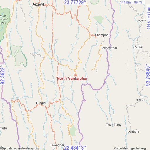
North Vanlaiphai GPS coordinates[2]
23° 7' 56.172" North, 93° 3' 55.152" East
| Map corner | latitude | longitude |
|---|---|---|
| Upper-left | 23.77729°, | 92.3622° |
| Center: | 23.13227°, | 93.06532° |
| Lower-right: | 22.48413°, | 93.76845° |
| Map W x H: | 143.8×143.8 km | = 89.4×89.4mi |
| max Lat: | 34.9274° ⇑47.5% North |
| North Vanlaiphai: | 23.13227° |
| min Lat: | ⇓52.5% South 8.09008° |
| min Long | North Vanlaipha | max Long |
| 68.82655° | 93.06532° | 96.81° |
| W 97.9%⇐ | ⇒2.1% E |
Elevation
Elevation of North Vanlaiphai is 1385 m = 4544 ft, and this is 1089.4 m = 3574 ft above average elevation for this country.
| Max E: |
3681 m = 12077 ft | 2.5% |
| North Vanlaiphai | 1385 m 4544 ft | |
| Avg. | 295.6 m = 970 ft | |
Min E: |
1 m = 3 ft | 97.5% |
See also: India elevation on elevation.city.
Geographical zone
North Vanlaiphai is located in North Torrid zone (between Equator and Tropic of Cancer). Distance of this Northern Tropic circle is 33.9 km =21.1 mi to North.| Distance of | km | miles | from North Vanlaiphai |
|---|---|---|---|
| North Pole | 7435 | 4619.9 | to North |
| Arctic Circle | 4829.1 | 3000.7 | to North |
| Tropic Cancer | 33.9 | 21.1 | to North |
| Equator | 2572.1 | 1598.2 | to South |


Nearby cities:
15 places around North Vanlaiphai: (largest is in red/bold)
• Aizawl
75.2 km =46.7 mi,  331°
331°
• Amarpur
150.1 km =93.3 mi,  286°
286°
• Churāchāndpur
147.1 km =91.4 mi,  24°
24°
• Darlawn
99 km =61.5 mi,  351°
351°
• Khawhai
28.1 km =17.5 mi,  13°
13°
• Kolasib
127.6 km =79.3 mi,  342°
342°
• Lunglei
42.5 km =26.4 mi,  231°
231°
• Mamit
106.1 km =65.9 mi, 326°
• Pherzawl
126.3 km =78.5 mi, 5°
• Sabrūm
138 km =85.7 mi,  263°
263°
• Saiha
71.7 km =44.6 mi,  186°
186°
• Sairang
86.4 km =53.7 mi, 330°
• Serchhīp
28.6 km =17.8 mi,  308°
308°
• Sāitlaw
105.9 km =65.8 mi, 331°
• Thenzawl
38.2 km =23.7 mi,  302°
302°
Sources, notices
• [Note1] Compared only with cities in India existing in our database
• [Src1] Map data: © OpenStreetMap contributors (CC-BY-SA)
• [Src2] Other city data from geonames.org with taken over terms of usage.
• [Src3] Geographical zone / Annual Mean Temperature by Robert A. Rohde @ Wikipedia
