Kālīnagar geodata
Kālīnagar (Uttar Pradesh) is a populated place; located in India in Asia/Kolkata (GMT+5.5) time zone. With population of 10,728 people, there are 2864 cities with bigger population in this country. Compared to other cities in India, 87.3% of cities are located further ↓South; 68.4% of cities are located further ←West and 51.9% of cities have higher elevation than Kālīnagar. Note1


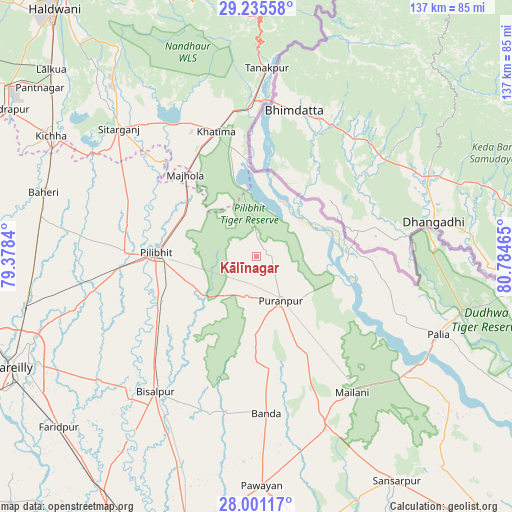
Kālīnagar GPS coordinates[2]
28° 37' 12.684" North, 80° 4' 53.472" East
| Map corner | latitude | longitude |
|---|---|---|
| Upper-left | 29.23558°, | 79.3784° |
| Center: | 28.62019°, | 80.08152° |
| Lower-right: | 28.00117°, | 80.78465° |
| Map W x H: | 137.3×137.3 km | = 85.3×85.3mi |
| max Lat: | 34.9274° ⇑12.7% North |
| Kālīnagar: | 28.62019° |
| min Lat: | ⇓87.3% South 8.09008° |
| min Long | Kālīnagar | max Long |
| 68.82655° | 80.08152° | 96.81° |
| W 68.4%⇐ | ⇒31.6% E |
Elevation
Elevation of Kālīnagar is 191 m = 627 ft, and this is 104.6 m = 343 ft below average elevation for this country.
| Max E: |
3681 m = 12077 ft | 51.9% |
| Avg. | 295.6 m = 970 ft | |
| Kālīnagar | 191 m = 627 ft | |
Min E: |
1 m = 3 ft | 48.1% |
See also: India elevation on elevation.city.
Geographical zone
Kālīnagar is located in North temperate zone (between Tropic of Cancer and the Arctic Circle). Distance of this Northern Tropic circle is 576.3 km =358.1 mi to South.| Distance of | km | miles | from Kālīnagar |
|---|---|---|---|
| North Pole | 6824.8 | 4240.7 | to North |
| Arctic Circle | 4218.9 | 2621.5 | to North |
| Tropic Cancer | 576.3 | 358.1 | to South |
| Equator | 3182.3 | 1977.4 | to South |


Nearby cities:
15 places around Kālīnagar: (largest is in red/bold)
• Banbasa
41.3 km =25.7 mi,  359°
359°
• Barkhera Kalān
32.7 km =20.3 mi,  235°
235°
• Bilsanda
43.8 km =27.2 mi,  196°
196°
• Bīsalpur
45.4 km =28.2 mi,  216°
216°
• Jahānābād
35.5 km =22.1 mi,  271°
271°
• Khatīma
35.2 km =21.9 mi,  342°
342°
• Khūtār
49.9 km =31 mi,  158°
158°
• Mailāni
44.7 km =27.8 mi,  144°
144°
• Mohanpur
43.9 km =27.3 mi, 158°
• Nawābganj
44.5 km =27.7 mi,  258°
258°
• Paliā Kalān
53.1 km =33 mi,  113°
113°
• Pīlibhīt
27.1 km =16.8 mi, 272°
• Pūranpur
13.6 km =8.5 mi,  151°
151°
• Sitārganj
50.3 km =31.3 mi,  313°
313°
• Tanakpur
50.5 km =31.4 mi,  3°
3°
Sources, notices
• [Note1] Compared only with cities in India existing in our database
• [Src1] Map data: © OpenStreetMap contributors (CC-BY-SA)
• [Src2] Other city data from geonames.org with taken over terms of usage.
• [Src3] Geographical zone / Annual Mean Temperature by Robert A. Rohde @ Wikipedia
