Karmāla geodata
Karmāla (Maharashtra) is a populated place; located in India in Asia/Kolkata (GMT+5.5) time zone. With population of 22,809 people, there are 1845 cities with bigger population in this country. Compared to other cities in India, 70.7% of cities are located further ↑North; 81% of cities are located further →East and 85.7% of cities have lower elevation than Karmāla. Note1


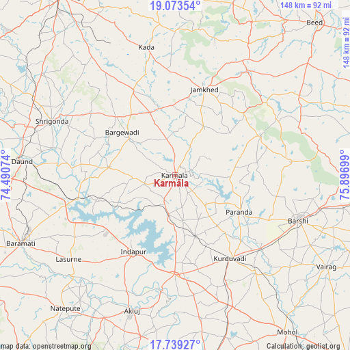
Karmāla GPS coordinates[2]
18° 24' 27.72" North, 75° 11' 37.896" East
| Map corner | latitude | longitude |
|---|---|---|
| Upper-left | 19.07354°, | 74.49074° |
| Center: | 18.4077°, | 75.19386° |
| Lower-right: | 17.73927°, | 75.89699° |
| Map W x H: | 148.4×148.4 km | = 92.2×92.2mi |
| max Lat: | 34.9274° ⇑70.7% North |
| Karmāla: | 18.4077° |
| min Lat: | ⇓29.3% South 8.09008° |
| min Long | Karmāla | max Long |
| 68.82655° | 75.19386° | 96.81° |
| W 19%⇐ | ⇒81% E |
Elevation
Elevation of Karmāla is 559 m = 1834 ft, and this is 263.4 m = 864 ft above average elevation for this country.
| Max E: |
3681 m = 12077 ft | 14.3% |
| Karmāla | 559 m 1834 ft | |
| Avg. | 295.6 m = 970 ft | |
Min E: |
1 m = 3 ft | 85.7% |
See also: India elevation on elevation.city.
Geographical zone
Karmāla is located in North Torrid zone (between Equator and Tropic of Cancer). Distance of this Northern Tropic circle is 559.2 km =347.5 mi to North.| Distance of | km | miles | from Karmāla |
|---|---|---|---|
| North Pole | 7960.3 | 4946.3 | to North |
| Arctic Circle | 5354.4 | 3327.1 | to North |
| Tropic Cancer | 559.2 | 347.5 | to North |
| Equator | 2046.7 | 1271.8 | to South |


Nearby cities:
15 places around Karmāla: (largest is in red/bold)
• Ahmadnagar
90.2 km =56 mi,  327°
327°
• Beed
87.7 km =54.5 mi,  42°
42°
• Bhigvan
46.6 km =29 mi,  255°
255°
• Bhūm
49.4 km =30.7 mi,  83°
83°
• Bārsi
56.1 km =34.9 mi,  110°
110°
• Bārāmati
71 km =44.1 mi,  246°
246°
• Daund
64.7 km =40.2 mi,  275°
275°
• Kalas
50 km =31.1 mi,  238°
238°
• Kurduvādi
42.1 km =26.2 mi,  146°
146°
• Kāti
88.6 km =55.1 mi,  124°
124°
• Osmanabad
92.7 km =57.6 mi, 105°
• Pandharpur
82.3 km =51.1 mi,  169°
169°
• Pāthardi
85.1 km =52.9 mi,  358°
358°
• Shrīgonda
57.1 km =35.5 mi,  293°
293°
• Ārangaon
85.3 km =53 mi,  323°
323°
Sources, notices
• [Note1] Compared only with cities in India existing in our database
• [Src1] Map data: © OpenStreetMap contributors (CC-BY-SA)
• [Src2] Other city data from geonames.org with taken over terms of usage.
• [Src3] Geographical zone / Annual Mean Temperature by Robert A. Rohde @ Wikipedia
