Lunglei geodata
Lunglei (Mizoram) is a populated place; located in India in Asia/Kolkata (GMT+5.5) time zone. With population of 52,728 people, there are 846 cities with bigger population in this country. Compared to other cities in India, 50.8% of cities are located further ↓South; 97.6% of cities are located further ←West and 96.2% of cities have lower elevation than Lunglei. Note1


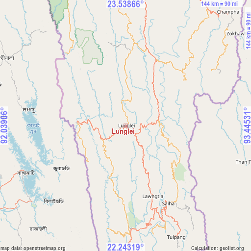
Lunglei GPS coordinates[2]
22° 53' 32.892" North, 92° 44' 31.848" East
| Map corner | latitude | longitude |
|---|---|---|
| Upper-left | 23.53866°, | 92.03906° |
| Center: | 22.89247°, | 92.74218° |
| Lower-right: | 22.24319°, | 93.44531° |
| Map W x H: | 144×144 km | = 89.5×89.5mi |
| max Lat: | 34.9274° ⇑49.2% North |
| Lunglei: | 22.89247° |
| min Lat: | ⇓50.8% South 8.09008° |
| min Long | Lunglei | max Long |
| 68.82655° | 92.74218° | 96.81° |
| W 97.6%⇐ | ⇒2.4% E |
Elevation
Elevation of Lunglei is 1014 m = 3327 ft, and this is 718.4 m = 2357 ft above average elevation for this country.
| Max E: |
3681 m = 12077 ft | 3.8% |
| Lunglei | 1014 m 3327 ft | |
| Avg. | 295.6 m = 970 ft | |
Min E: |
1 m = 3 ft | 96.2% |
See also: Lunglei elevation on elevation.city.
Geographical zone
Lunglei is located in North Torrid zone (between Equator and Tropic of Cancer). Distance of this Northern Tropic circle is 60.5 km =37.6 mi to North.| Distance of | km | miles | from Lunglei |
|---|---|---|---|
| North Pole | 7461.7 | 4636.5 | to North |
| Arctic Circle | 4855.8 | 3017.3 | to North |
| Tropic Cancer | 60.5 | 37.6 | to North |
| Equator | 2545.4 | 1581.6 | to South |


Nearby cities:
15 places around Lunglei: (largest is in red/bold)
• Aizawl
93 km =57.8 mi,  358°
358°
• Amarpur
131.2 km =81.5 mi,  302°
302°
• Belonia
137.7 km =85.6 mi,  286°
286°
• Darlawn
126 km =78.3 mi,  8°
8°
• Khawhai
66.9 km =41.6 mi,  36°
36°
• Mamit
117.9 km =73.3 mi,  347°
347°
• North Vanlaiphai
42.5 km =26.4 mi,  51°
51°
• Sabrūm
104.9 km =65.2 mi,  276°
276°
• Saiha
50.9 km =31.6 mi,  151°
151°
• Sairang
102.5 km =63.7 mi, 354°
• Serchhīp
45.8 km =28.5 mi, 13°
• Sāitlaw
121.2 km =75.3 mi, 351°
• Thenzawl
47.2 km =29.3 mi,  0°
0°
• Udaipur
147.1 km =91.4 mi, 298°
• Āmbāsa
147.2 km =91.5 mi,  322°
322°
Sources, notices
• [Note1] Compared only with cities in India existing in our database
• [Src1] Map data: © OpenStreetMap contributors (CC-BY-SA)
• [Src2] Other city data from geonames.org with taken over terms of usage.
• [Src3] Geographical zone / Annual Mean Temperature by Robert A. Rohde @ Wikipedia
