Samdari geodata
Samdari (Rajasthan) is a populated place; located in India in Asia/Kolkata (GMT+5.5) time zone. With population of 17,915 people, there are 2208 cities with bigger population in this country. Compared to other cities in India, 69.1% of cities are located further ↓South; 96.7% of cities are located further →East and 60.9% of cities have higher elevation than Samdari. Note1


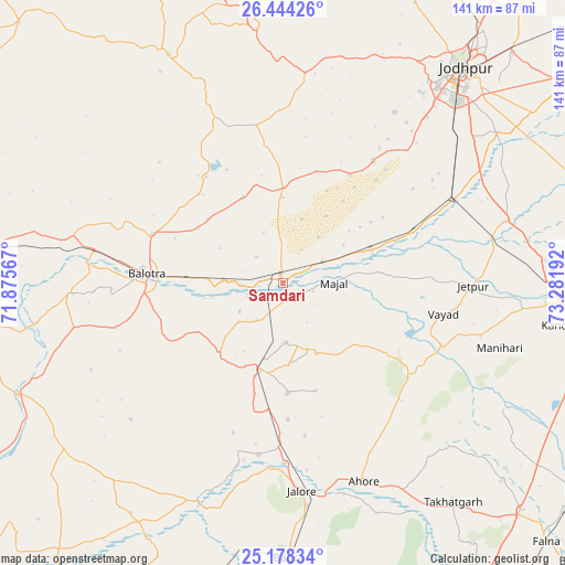
Samdari GPS coordinates[2]
25° 48' 46.764" North, 72° 34' 43.644" East
| Map corner | latitude | longitude |
|---|---|---|
| Upper-left | 26.44426°, | 71.87567° |
| Center: | 25.81299°, | 72.57879° |
| Lower-right: | 25.17834°, | 73.28192° |
| Map W x H: | 140.8×140.8 km | = 87.5×87.5mi |
| max Lat: | 34.9274° ⇑30.9% North |
| Samdari: | 25.81299° |
| min Lat: | ⇓69.1% South 8.09008° |
| min Long | Samdari | max Long |
| 68.82655° | 72.57879° | 96.81° |
| W 3.3%⇐ | ⇒96.7% E |
Elevation
Elevation of Samdari is 143 m = 469 ft, and this is 152.6 m = 501 ft below average elevation for this country.
| Max E: |
3681 m = 12077 ft | 60.9% |
| Avg. | 295.6 m = 970 ft | |
| Samdari | 143 m = 469 ft | |
Min E: |
1 m = 3 ft | 39.1% |
See also: India elevation on elevation.city.
Geographical zone
Samdari is located in North temperate zone (between Tropic of Cancer and the Arctic Circle). Distance of this Northern Tropic circle is 264.2 km =164.2 mi to South.| Distance of | km | miles | from Samdari |
|---|---|---|---|
| North Pole | 7136.9 | 4434.7 | to North |
| Arctic Circle | 4531 | 2815.4 | to North |
| Tropic Cancer | 264.2 | 164.2 | to South |
| Equator | 2870.1 | 1783.4 | to South |


Nearby cities:
15 places around Samdari: (largest is in red/bold)
• Bhīnmāl
95.6 km =59.4 mi,  198°
198°
• Bāli
99 km =61.5 mi,  133°
133°
• Bālotra
34 km =21.1 mi,  273°
273°
• Bārmer
119 km =73.9 mi, 266°
• Jalor
52.1 km =32.4 mi,  175°
175°
• Jodhpur
66.2 km =41.1 mi,  40°
40°
• Pāli
74.7 km =46.4 mi,  93°
93°
• Pīpār
115.4 km =71.7 mi,  56°
56°
• Rāni
89.5 km =55.6 mi, 125°
• Sheoganj
89.6 km =55.7 mi,  146°
146°
• Sirohi
106.3 km =66.1 mi,  165°
165°
• Siwāna
23.8 km =14.8 mi,  221°
221°
• Sojat
109.5 km =68 mi,  83°
83°
• Sādri
112.1 km =69.7 mi, 128°
• Takhatgarh
69.3 km =43.1 mi,  141°
141°
Sources, notices
• [Note1] Compared only with cities in India existing in our database
• [Src1] Map data: © OpenStreetMap contributors (CC-BY-SA)
• [Src2] Other city data from geonames.org with taken over terms of usage.
• [Src3] Geographical zone / Annual Mean Temperature by Robert A. Rohde @ Wikipedia
