Takhatgarh geodata
Takhatgarh (Rajasthan) is a populated place; located in India in Asia/Kolkata (GMT+5.5) time zone. With population of 17,285 people, there are 2258 cities with bigger population in this country. Compared to other cities in India, 65.4% of cities are located further ↓South; 94.6% of cities are located further →East and 54.5% of cities have lower elevation than Takhatgarh. Note1


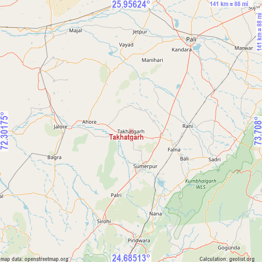
Takhatgarh GPS coordinates[2]
25° 19' 20.46" North, 73° 0' 17.532" East
| Map corner | latitude | longitude |
|---|---|---|
| Upper-left | 25.95624°, | 72.30175° |
| Center: | 25.32235°, | 73.00487° |
| Lower-right: | 24.68513°, | 73.708° |
| Map W x H: | 141.3×141.3 km | = 87.8×87.8mi |
| max Lat: | 34.9274° ⇑34.6% North |
| Takhatgarh: | 25.32235° |
| min Lat: | ⇓65.4% South 8.09008° |
| min Long | Takhatgarh | max Long |
| 68.82655° | 73.00487° | 96.81° |
| W 5.4%⇐ | ⇒94.6% E |
Elevation
Elevation of Takhatgarh is 224 m = 735 ft, and this is 71.6 m = 235 ft below average elevation for this country.
| Max E: |
3681 m = 12077 ft | 45.5% |
| Avg. | 295.6 m = 970 ft | |
| Takhatgarh | 224 m = 735 ft | |
Min E: |
1 m = 3 ft | 54.5% |
See also: India elevation on elevation.city.
Geographical zone
Takhatgarh is located in North temperate zone (between Tropic of Cancer and the Arctic Circle). Distance of this Northern Tropic circle is 209.7 km =130.3 mi to South.| Distance of | km | miles | from Takhatgarh |
|---|---|---|---|
| North Pole | 7191.5 | 4468.6 | to North |
| Arctic Circle | 4585.6 | 2849.4 | to North |
| Tropic Cancer | 209.7 | 130.3 | to South |
| Equator | 2815.6 | 1749.5 | to South |


Nearby cities:
15 places around Takhatgarh: (largest is in red/bold)
• Amet
92.6 km =57.5 mi,  91°
91°
• Bhīnmāl
82.1 km =51 mi,  244°
244°
• Bāli
32 km =19.9 mi,  115°
115°
• Jalor
39.2 km =24.4 mi,  273°
273°
• Nāthdwāra
92.9 km =57.7 mi, 117°
• Pindwāra
58.6 km =36.4 mi,  175°
175°
• Pāli
59.4 km =36.9 mi,  32°
32°
• Rājsamand
92.3 km =57.4 mi,  107°
107°
• Rāni
30.7 km =19.1 mi,  84°
84°
• Samdari
69.3 km =43.1 mi,  321°
321°
• Sheoganj
21.3 km =13.2 mi,  162°
162°
• Sirohi
50.8 km =31.6 mi,  198°
198°
• Siwāna
69 km =42.9 mi,  302°
302°
• Sādri
47.6 km =29.6 mi, 108°
• Ābu
86 km =53.4 mi, 199°
Sources, notices
• [Note1] Compared only with cities in India existing in our database
• [Src1] Map data: © OpenStreetMap contributors (CC-BY-SA)
• [Src2] Other city data from geonames.org with taken over terms of usage.
• [Src3] Geographical zone / Annual Mean Temperature by Robert A. Rohde @ Wikipedia
