Shahdol geodata
Shahdol (Madhya Pradesh) is a populated place; located in India in Asia/Kolkata (GMT+5.5) time zone. With population of 89,289 people, there are 500 cities with bigger population in this country. Compared to other cities in India, 53.6% of cities are located further ↓South; 74.1% of cities are located further ←West and 80.6% of cities have lower elevation than Shahdol. Note1


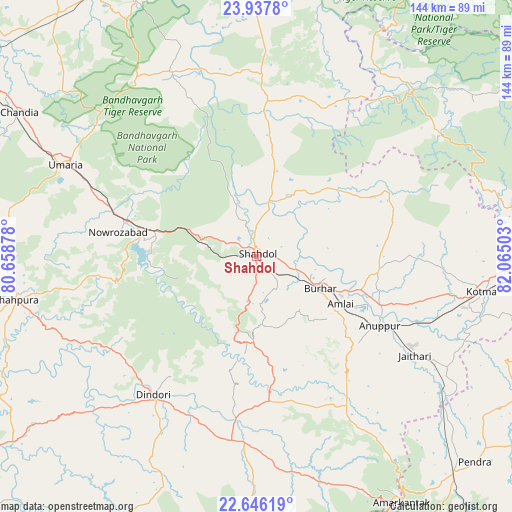
Shahdol GPS coordinates[2]
23° 17' 36.816" North, 81° 21' 42.84" East
| Map corner | latitude | longitude |
|---|---|---|
| Upper-left | 23.9378°, | 80.65878° |
| Center: | 23.29356°, | 81.3619° |
| Lower-right: | 22.64619°, | 82.06503° |
| Map W x H: | 143.6×143.6 km | = 89.2×89.2mi |
| max Lat: | 34.9274° ⇑46.4% North |
| Shahdol: | 23.29356° |
| min Lat: | ⇓53.6% South 8.09008° |
| min Long | Shahdol | max Long |
| 68.82655° | 81.3619° | 96.81° |
| W 74.1%⇐ | ⇒25.9% E |
Elevation
Elevation of Shahdol is 468 m = 1535 ft, and this is 172.4 m = 566 ft above average elevation for this country.
| Max E: |
3681 m = 12077 ft | 19.4% |
| Shahdol | 468 m 1535 ft | |
| Avg. | 295.6 m = 970 ft | |
Min E: |
1 m = 3 ft | 80.6% |
See also: Shahdol elevation on elevation.city.
Geographical zone
Shahdol is located in North Torrid zone (between Equator and Tropic of Cancer). Distance of this Northern Tropic circle is 15.9 km =9.9 mi to North.| Distance of | km | miles | from Shahdol |
|---|---|---|---|
| North Pole | 7417.1 | 4608.8 | to North |
| Arctic Circle | 4811.2 | 2989.5 | to North |
| Tropic Cancer | 15.9 | 9.9 | to North |
| Equator | 2590 | 1609.4 | to South |


Nearby cities:
15 places around Shahdol: (largest is in red/bold)
• Amarkantak
79.9 km =49.6 mi,  149°
149°
• Anūppur
39.7 km =24.7 mi,  122°
122°
• Barhi
87.7 km =54.5 mi,  320°
320°
• Beohāri
81.3 km =50.5 mi,  1°
1°
• Bodri
16 km =9.9 mi, 153°
• Burhar
19.5 km =12.1 mi, 116°
• Chandia
77.8 km =48.3 mi,  301°
301°
• Dindori
48.6 km =30.2 mi,  216°
216°
• Gaurela
81.5 km =50.6 mi,  137°
137°
• Jaisinghnagar
43.7 km =27.2 mi, 3°
• Kotma
63.8 km =39.6 mi,  98°
98°
• Pendra
84 km =52.2 mi,  133°
133°
• Pāli
33.4 km =20.8 mi,  283°
283°
• Shāhpur
47.3 km =29.4 mi,  230°
230°
• Umaria
59.4 km =36.9 mi, 295°
Sources, notices
• [Note1] Compared only with cities in India existing in our database
• [Src1] Map data: © OpenStreetMap contributors (CC-BY-SA)
• [Src2] Other city data from geonames.org with taken over terms of usage.
• [Src3] Geographical zone / Annual Mean Temperature by Robert A. Rohde @ Wikipedia
