Nawābganj geodata
Nawābganj (Uttar Pradesh) is a populated place; located in India in Asia/Kolkata (GMT+5.5) time zone. With population of 17,015 people, there are 2284 cities with bigger population in this country. Compared to other cities in India, 77.3% of cities are located further ↓South; 77% of cities are located further ←West and 68.5% of cities have higher elevation than Nawābganj. Note1


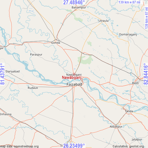
Nawābganj GPS coordinates[2]
26° 51' 50.256" North, 82° 8' 27.708" East
| Map corner | latitude | longitude |
|---|---|---|
| Upper-left | 27.48946°, | 81.43791° |
| Center: | 26.86396°, | 82.14103° |
| Lower-right: | 26.23499°, | 82.84416° |
| Map W x H: | 139.5×139.5 km | = 86.7×86.7mi |
| max Lat: | 34.9274° ⇑22.7% North |
| Nawābganj: | 26.86396° |
| min Lat: | ⇓77.3% South 8.09008° |
| min Long | Nawābganj | max Long |
| 68.82655° | 82.14103° | 96.81° |
| W 77%⇐ | ⇒23% E |
Elevation
Elevation of Nawābganj is 100 m = 328 ft, and this is 195.6 m = 642 ft below average elevation for this country.
| Max E: |
3681 m = 12077 ft | 68.5% |
| Avg. | 295.6 m = 970 ft | |
| Nawābganj | 100 m = 328 ft | |
Min E: |
1 m = 3 ft | 31.5% |
See also: India elevation on elevation.city.
Geographical zone
Nawābganj is located in North temperate zone (between Tropic of Cancer and the Arctic Circle). Distance of this Northern Tropic circle is 381.1 km =236.8 mi to South.| Distance of | km | miles | from Nawābganj |
|---|---|---|---|
| North Pole | 7020.1 | 4362.1 | to North |
| Arctic Circle | 4414.2 | 2742.9 | to North |
| Tropic Cancer | 381.1 | 236.8 | to South |
| Equator | 2987 | 1856 | to South |


Nearby cities:
15 places around Nawābganj: (largest is in red/bold)
• Ajodhya
9.6 km =6 mi,  138°
138°
• Akbarpur
62.1 km =38.6 mi, 141°
• Balrāmpur
63 km =39.1 mi,  3°
3°
• Bastī
57.7 km =35.9 mi,  98°
98°
• Bīkāpur
29.9 km =18.6 mi,  181°
181°
• Colonelganj
53.1 km =33 mi,  304°
304°
• Fyzābād
9.9 km =6.2 mi,  174°
174°
• Gondā City
35.1 km =21.8 mi,  328°
328°
• Goshāinganj
40.3 km =25 mi, 143°
• Haraiya
33 km =20.5 mi, 103°
• Khargupur
58.9 km =36.6 mi,  345°
345°
• Mankāpur
22.7 km =14.1 mi,  22°
22°
• Tikaitnagar
57.8 km =35.9 mi,  279°
279°
• Tāndā
62.2 km =38.6 mi,  124°
124°
• Utraula
57.6 km =35.8 mi,  28°
28°
Sources, notices
• [Note1] Compared only with cities in India existing in our database
• [Src1] Map data: © OpenStreetMap contributors (CC-BY-SA)
• [Src2] Other city data from geonames.org with taken over terms of usage.
• [Src3] Geographical zone / Annual Mean Temperature by Robert A. Rohde @ Wikipedia
