Mankāpur geodata
Mankāpur (Uttar Pradesh) is a populated place; located in India in Asia/Kolkata (GMT+5.5) time zone. With population of 9,746 people, there are 2971 cities with bigger population in this country. Compared to other cities in India, 78.8% of cities are located further ↓South; 77.4% of cities are located further ←West and 68.1% of cities have higher elevation than Mankāpur. Note1


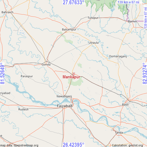
Mankāpur GPS coordinates[2]
27° 3' 6.804" North, 82° 13' 46.596" East
| Map corner | latitude | longitude |
|---|---|---|
| Upper-left | 27.67633°, | 81.52649° |
| Center: | 27.05189°, | 82.22961° |
| Lower-right: | 26.42395°, | 82.93274° |
| Map W x H: | 139.3×139.3 km | = 86.6×86.6mi |
| max Lat: | 34.9274° ⇑21.2% North |
| Mankāpur: | 27.05189° |
| min Lat: | ⇓78.8% South 8.09008° |
| min Long | Mankāpur | max Long |
| 68.82655° | 82.22961° | 96.81° |
| W 77.4%⇐ | ⇒22.6% E |
Elevation
Elevation of Mankāpur is 102 m = 335 ft, and this is 193.6 m = 635 ft below average elevation for this country.
| Max E: |
3681 m = 12077 ft | 68.1% |
| Avg. | 295.6 m = 970 ft | |
| Mankāpur | 102 m = 335 ft | |
Min E: |
1 m = 3 ft | 31.9% |
See also: India elevation on elevation.city.
Geographical zone
Mankāpur is located in North temperate zone (between Tropic of Cancer and the Arctic Circle). Distance of this Northern Tropic circle is 402 km =249.8 mi to South.| Distance of | km | miles | from Mankāpur |
|---|---|---|---|
| North Pole | 6999.2 | 4349.1 | to North |
| Arctic Circle | 4393.3 | 2729.9 | to North |
| Tropic Cancer | 402 | 249.8 | to South |
| Equator | 3007.9 | 1869 | to South |


Nearby cities:
15 places around Mankāpur: (largest is in red/bold)
• Ajodhya
28.2 km =17.5 mi,  185°
185°
• Balrāmpur
42.2 km =26.2 mi,  354°
354°
• Bastī
56.5 km =35.1 mi,  121°
121°
• Bīkāpur
51.7 km =32.1 mi, 190°
• Colonelganj
53.3 km =33.1 mi,  279°
279°
• Fyzābād
31.7 km =19.7 mi, 194°
• Gondā City
28.8 km =17.9 mi,  287°
287°
• Goshāinganj
55.5 km =34.5 mi,  164°
164°
• Haraiya
36.9 km =22.9 mi,  140°
140°
• Ikauna
59.2 km =36.8 mi,  334°
334°
• Katra
54.6 km =33.9 mi,  338°
338°
• Khargupur
43.2 km =26.8 mi, 326°
• Nawābganj
22.7 km =14.1 mi,  202°
202°
• Tulsīpur
56.7 km =35.2 mi,  19°
19°
• Utraula
35.1 km =21.8 mi,  32°
32°
Sources, notices
• [Note1] Compared only with cities in India existing in our database
• [Src1] Map data: © OpenStreetMap contributors (CC-BY-SA)
• [Src2] Other city data from geonames.org with taken over terms of usage.
• [Src3] Geographical zone / Annual Mean Temperature by Robert A. Rohde @ Wikipedia
