Bārsi geodata
Bārsi (Maharashtra) is a populated place; located in India in Asia/Kolkata (GMT+5.5) time zone. With population of 110,983 people, there are 403 cities with bigger population in this country. Compared to other cities in India, 71.2% of cities are located further ↑North; 76.7% of cities are located further →East and 83.6% of cities have lower elevation than Bārsi. Note1


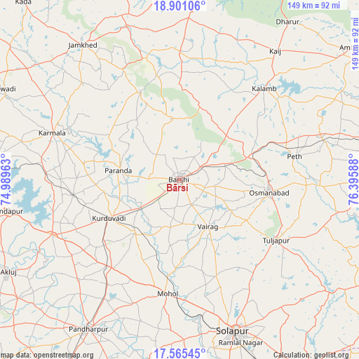
Bārsi GPS coordinates[2]
18° 14' 4.344" North, 75° 41' 33.9" East
| Map corner | latitude | longitude |
|---|---|---|
| Upper-left | 18.90106°, | 74.98963° |
| Center: | 18.23454°, | 75.69275° |
| Lower-right: | 17.56545°, | 76.39588° |
| Map W x H: | 148.5×148.5 km | = 92.3×92.3mi |
| max Lat: | 34.9274° ⇑71.2% North |
| Bārsi: | 18.23454° |
| min Lat: | ⇓28.8% South 8.09008° |
| min Long | Bārsi | max Long |
| 68.82655° | 75.69275° | 96.81° |
| W 23.3%⇐ | ⇒76.7% E |
Elevation
Elevation of Bārsi is 518 m = 1699 ft, and this is 222.4 m = 730 ft above average elevation for this country.
| Max E: |
3681 m = 12077 ft | 16.4% |
| Bārsi | 518 m 1699 ft | |
| Avg. | 295.6 m = 970 ft | |
Min E: |
1 m = 3 ft | 83.6% |
See also: Bārsi elevation on elevation.city.
Geographical zone
Bārsi is located in North Torrid zone (between Equator and Tropic of Cancer). Distance of this Northern Tropic circle is 578.4 km =359.4 mi to North.| Distance of | km | miles | from Bārsi |
|---|---|---|---|
| North Pole | 7979.6 | 4958.3 | to North |
| Arctic Circle | 5373.7 | 3339.1 | to North |
| Tropic Cancer | 578.4 | 359.4 | to North |
| Equator | 2027.5 | 1259.8 | to South |


Nearby cities:
15 places around Bārsi: (largest is in red/bold)
• Ambājogāi
91.8 km =57 mi,  52°
52°
• Ausa
85.2 km =52.9 mi,  89°
89°
• Beed
84.2 km =52.3 mi,  4°
4°
• Bhūm
25.2 km =15.7 mi,  351°
351°
• Dhārūr
78.5 km =48.8 mi,  34°
34°
• Kalas
95.6 km =59.4 mi,  265°
265°
• Karmāla
56.1 km =34.9 mi,  290°
290°
• Kurduvādi
33.2 km =20.6 mi,  241°
241°
• Kāti
36.8 km =22.9 mi,  145°
145°
• Latur
94.1 km =58.5 mi,  78°
78°
• Naldurg
77.7 km =48.3 mi,  126°
126°
• Osmanabad
37 km =23 mi,  99°
99°
• Pandharpur
72.6 km =45.1 mi,  211°
211°
• Solāpur
66.7 km =41.4 mi,  159°
159°
• Tuljāpur
47.2 km =29.3 mi,  122°
122°
Sources, notices
• [Note1] Compared only with cities in India existing in our database
• [Src1] Map data: © OpenStreetMap contributors (CC-BY-SA)
• [Src2] Other city data from geonames.org with taken over terms of usage.
• [Src3] Geographical zone / Annual Mean Temperature by Robert A. Rohde @ Wikipedia
