Rāvar geodata
Rāvar (Kerman) is a seat of a second-order administrative division; located in Iran in Asia/Tehran (GMT+3.5) time zone. With population of 40,167 people, there are 151 cities with bigger population in this country. Compared to other cities in Iran, 74.6% of cities are located further ↑North; 83% of cities are located further ←West and 50.8% of cities have lower elevation than Rāvar. Note1


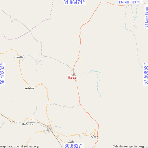
Rāvar GPS coordinates[2]
31° 15' 56.232" North, 56° 48' 19.62" East
| Map corner | latitude | longitude |
|---|---|---|
| Upper-left | 31.86471°, | 56.10233° |
| Center: | 31.26562°, | 56.80545° |
| Lower-right: | 30.6627°, | 57.50858° |
| Map W x H: | 133.7×133.7 km | = 83.1×83.1mi |
| max Lat: | 39.6482° ⇑74.6% North |
| Rāvar: | 31.26562° |
| min Lat: | ⇓25.4% South 25.2919° |
| min Long | Rāvar | max Long |
| 44.38416° | 56.80545° | 61.9965° |
| W 83%⇐ | ⇒17% E |
Elevation
Elevation of Rāvar is 1181 m = 3875 ft, and this is 132 m = 433 ft above average elevation for this country.
| Max E: |
2564 m = 8412 ft | 49.2% |
| Rāvar | 1181 m 3875 ft | |
| Avg. | 1049 m = 3442 ft | |
Min E: |
-24 m = -79 ft | 50.8% |
See also: Rāvar elevation on elevation.city.
Geographical zone
Rāvar is located in North temperate zone (between Tropic of Cancer and the Arctic Circle). Distance of this Northern Tropic circle is 870.5 km =540.9 mi to South.| Distance of | km | miles | from Rāvar |
|---|---|---|---|
| North Pole | 6530.7 | 4058 | to North |
| Arctic Circle | 3924.8 | 2438.8 | to North |
| Tropic Cancer | 870.5 | 540.9 | to South |
| Equator | 3476.4 | 2160.1 | to South |


Nearby cities:
15 places around Rāvar: (largest is in red/bold)
• Anār
152.7 km =94.9 mi,  253°
253°
• Bahābād
100 km =62.1 mi,  312°
312°
• Bardsīr
151 km =93.8 mi,  188°
188°
• Bāfq
138.3 km =85.9 mi,  285°
285°
• Bāft
226.8 km =140.9 mi,  184°
184°
• Kerman
112.3 km =69.8 mi,  166°
166°
• Kūh Sefīd
221.2 km =137.4 mi, 180°
• Kūhbanān
52.2 km =32.4 mi, 287°
• Mahrīz
226.9 km =141 mi,  278°
278°
• Rafsanjān
123 km =76.4 mi,  219°
219°
• Rābor
219.8 km =136.6 mi, 177°
• Shahr-e Bābak
205.8 km =127.9 mi,  231°
231°
• Shahrak-e Pābedānā
41.4 km =25.7 mi, 249°
• Sirjan
228.8 km =142.2 mi,  208°
208°
• Zarand
55.4 km =34.4 mi,  204°
204°
Sources, notices
• [Note1] Compared only with cities in Iran existing in our database
• [Src1] Map data: © OpenStreetMap contributors (CC-BY-SA)
• [Src2] Other city data from geonames.org with taken over terms of usage.
• [Src3] Geographical zone / Annual Mean Temperature by Robert A. Rohde @ Wikipedia
