Kūhbanān geodata
Kūhbanān (Kerman) is a seat of a second-order administrative division; located in Iran in Asia/Tehran (GMT+3.5) time zone. In our database, there are 232 cities with bigger population. Compared to other cities in Iran, 73.7% of cities are located further ↑North; 81% of cities are located further ←West and 93.4% of cities have lower elevation than Kūhbanān. Note1


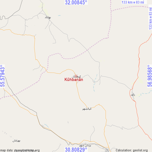
Kūhbanān GPS coordinates[2]
31° 24' 37.044" North, 56° 16' 57.18" East
| Map corner | latitude | longitude |
|---|---|---|
| Upper-left | 32.00845°, | 55.57943° |
| Center: | 31.41029°, | 56.28255° |
| Lower-right: | 30.80829°, | 56.98568° |
| Map W x H: | 133.4×133.4 km | = 82.9×82.9mi |
| max Lat: | 39.6482° ⇑73.7% North |
| Kūhbanān: | 31.41029° |
| min Lat: | ⇓26.3% South 25.2919° |
| min Long | Kūhbanān | max Long |
| 44.38416° | 56.28255° | 61.9965° |
| W 81%⇐ | ⇒19% E |
Elevation
Elevation of Kūhbanān is 1990 m = 6529 ft, and this is 941 m = 3087 ft above average elevation for this country.
| Max E: |
2564 m = 8412 ft | 6.6% |
| Kūhbanān | 1990 m 6529 ft | |
| Avg. | 1049 m = 3442 ft | |
Min E: |
-24 m = -79 ft | 93.4% |
See also: Iran elevation on elevation.city.
Geographical zone
Kūhbanān is located in North temperate zone (between Tropic of Cancer and the Arctic Circle). Distance of this Northern Tropic circle is 886.6 km =550.9 mi to South.| Distance of | km | miles | from Kūhbanān |
|---|---|---|---|
| North Pole | 6514.6 | 4048 | to North |
| Arctic Circle | 3908.7 | 2428.8 | to North |
| Tropic Cancer | 886.6 | 550.9 | to South |
| Equator | 3492.5 | 2170.1 | to South |


Nearby cities:
15 places around Kūhbanān: (largest is in red/bold)
• Anār
113.5 km =70.5 mi,  238°
238°
• Bahābād
56.8 km =35.3 mi,  334°
334°
• Bardsīr
167.7 km =104.2 mi,  170°
170°
• Bāfq
86.1 km =53.5 mi,  284°
284°
• Kerman
146.6 km =91.1 mi,  148°
148°
• Mahrīz
175.5 km =109.1 mi, 276°
• Rafsanjān
114.9 km =71.4 mi,  193°
193°
• Rāvar
52.2 km =32.4 mi,  107°
107°
• Shahr-e Bābak
181.8 km =113 mi,  217°
217°
• Shahrak-e Pābedānā
32.6 km =20.3 mi,  160°
160°
• Sirjan
225.3 km =140 mi, 194°
• Taft
198.9 km =123.6 mi, 281°
• Taft
200.5 km =124.6 mi, 280°
• Yazd
189.2 km =117.6 mi,  286°
286°
• Zarand
71.6 km =44.5 mi, 158°
Sources, notices
• [Note1] Compared only with cities in Iran existing in our database
• [Src1] Map data: © OpenStreetMap contributors (CC-BY-SA)
• [Src2] Other city data from geonames.org with taken over terms of usage.
• [Src3] Geographical zone / Annual Mean Temperature by Robert A. Rohde @ Wikipedia
