Khorramshahr geodata
Khorramshahr (Khuzestan) is a seat of a second-order administrative division; located in Iran in Asia/Tehran (GMT+3.5) time zone. With population of 330,606 people, there are 25 cities with bigger population in this country. Compared to other cities in Iran, 79.8% of cities are located further ↑North; 80.5% of cities are located further →East and 95% of cities have higher elevation than Khorramshahr. Note1


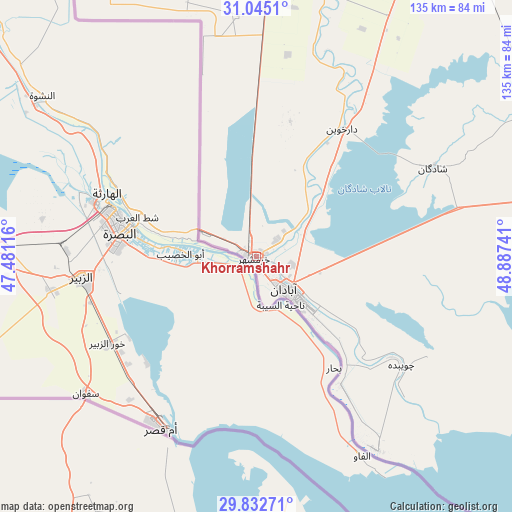
Khorramshahr GPS coordinates[2]
30° 26' 26.844" North, 48° 11' 3.408" East
| Map corner | latitude | longitude |
|---|---|---|
| Upper-left | 31.0451°, | 47.48116° |
| Center: | 30.44079°, | 48.18428° |
| Lower-right: | 29.83271°, | 48.88741° |
| Map W x H: | 134.8×134.8 km | = 83.8×83.8mi |
| max Lat: | 39.6482° ⇑79.8% North |
| Khorramshahr: | 30.44079° |
| min Lat: | ⇓20.2% South 25.2919° |
| min Long | Khorramshahr | max Long |
| 44.38416° | 48.18428° | 61.9965° |
| W 19.5%⇐ | ⇒80.5% E |
Elevation
Elevation of Khorramshahr is 4 m = 13 ft, and this is 1045 m = 3428 ft below average elevation for this country.
| Max E: |
2564 m = 8412 ft | 95% |
| Avg. | 1049 m = 3442 ft | |
| Khorramshahr | 4 m = 13 ft | |
Min E: |
-24 m = -79 ft | 5% |
See also: Khorramshahr elevation on elevation.city.
Geographical zone
Khorramshahr is located in North temperate zone (between Tropic of Cancer and the Arctic Circle). Distance of this Northern Tropic circle is 778.8 km =483.9 mi to South.| Distance of | km | miles | from Khorramshahr |
|---|---|---|---|
| North Pole | 6622.4 | 4115 | to North |
| Arctic Circle | 4016.5 | 2495.7 | to North |
| Tropic Cancer | 778.8 | 483.9 | to South |
| Equator | 3384.7 | 2103.2 | to South |


Nearby cities:
15 places around Khorramshahr: (largest is in red/bold)
• Abadan
16.1 km =10 mi,  134°
134°
• Aghajari
160.3 km =99.6 mi,  79°
79°
• Ahvaz
108.7 km =67.5 mi,  26°
26°
• Bandar-e Emam Khomeyni
88.1 km =54.7 mi,  90°
90°
• Bandar-e Māhshahr
97.1 km =60.3 mi, 82°
• Hendījān
148.3 km =92.1 mi,  98°
98°
• Hoveyzeh
114 km =70.8 mi,  354°
354°
• Jongīyeh
99.6 km =61.9 mi,  24°
24°
• Mollās̄ānī
143.7 km =89.3 mi, 27°
• Omīdīyeh
149.6 km =93 mi, 76°
• Rāmhormoz
164.5 km =102.2 mi,  55°
55°
• Rāmshīr
127.4 km =79.2 mi,  66°
66°
• Shādegān
51.5 km =32 mi, 63°
• Sūsangerd
124.8 km =77.5 mi,  0°
0°
• sedeyen-e Yek
119 km =73.9 mi, 30°
In other languages:
- In Spanish: Jorramchar
- In German: Chorramschahr
- In Russian: Хорремшехр
- In Chinese: 霍拉姆沙赫尔
Sources, notices
• [Note1] Compared only with cities in Iran existing in our database
• [Src1] Map data: © OpenStreetMap contributors (CC-BY-SA)
• [Src2] Other city data from geonames.org with taken over terms of usage.
• [Src3] Geographical zone / Annual Mean Temperature by Robert A. Rohde @ Wikipedia
