Sūsangerd geodata
Sūsangerd (Khuzestan) is a seat of a second-order administrative division; located in Iran in Asia/Tehran (GMT+3.5) time zone. With population of 41,443 people, there are 149 cities with bigger population in this country. Compared to other cities in Iran, 72.1% of cities are located further ↑North; 80.3% of cities are located further →East and 90.2% of cities have higher elevation than Sūsangerd. Note1


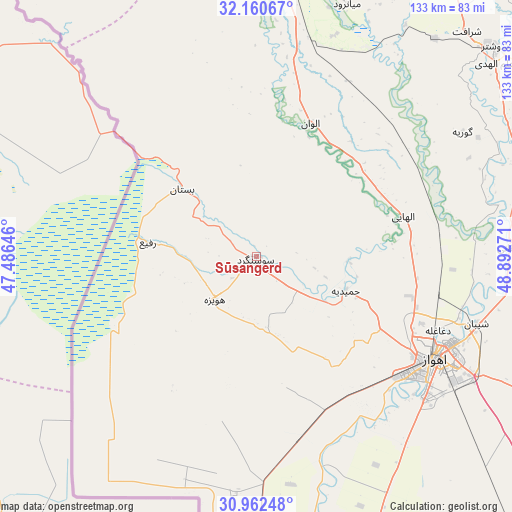
Sūsangerd GPS coordinates[2]
31° 33' 48.6" North, 48° 11' 22.488" East
| Map corner | latitude | longitude |
|---|---|---|
| Upper-left | 32.16067°, | 47.48646° |
| Center: | 31.5635°, | 48.18958° |
| Lower-right: | 30.96248°, | 48.89271° |
| Map W x H: | 133.2×133.2 km | = 82.8×82.8mi |
| max Lat: | 39.6482° ⇑72.1% North |
| Sūsangerd: | 31.5635° |
| min Lat: | ⇓27.9% South 25.2919° |
| min Long | Sūsangerd | max Long |
| 44.38416° | 48.18958° | 61.9965° |
| W 19.7%⇐ | ⇒80.3% E |
Elevation
Elevation of Sūsangerd is 15 m = 49 ft, and this is 1034 m = 3392 ft below average elevation for this country.
| Max E: |
2564 m = 8412 ft | 90.2% |
| Avg. | 1049 m = 3442 ft | |
| Sūsangerd | 15 m = 49 ft | |
Min E: |
-24 m = -79 ft | 9.8% |
See also: Sūsangerd elevation on elevation.city.
Geographical zone
Sūsangerd is located in North temperate zone (between Tropic of Cancer and the Arctic Circle). Distance of this Northern Tropic circle is 903.6 km =561.5 mi to South.| Distance of | km | miles | from Sūsangerd |
|---|---|---|---|
| North Pole | 6497.5 | 4037.4 | to North |
| Arctic Circle | 3891.6 | 2418.1 | to North |
| Tropic Cancer | 903.6 | 561.5 | to South |
| Equator | 3509.5 | 2180.7 | to South |


Nearby cities:
15 places around Sūsangerd: (largest is in red/bold)
• Ahvaz
54.2 km =33.7 mi,  120°
120°
• Andīmeshk
101 km =62.8 mi,  8°
8°
• Dasht-e Lati
120.5 km =74.9 mi,  45°
45°
• Dezful
93.2 km =57.9 mi, 12°
• Haftkel
127.7 km =79.3 mi,  95°
95°
• Hoveyzeh
15.7 km =9.8 mi,  224°
224°
• Jongīyeh
53 km =32.9 mi,  130°
130°
• Khorramshahr
124.8 km =77.5 mi,  180°
180°
• Masjed Soleymān
113.2 km =70.3 mi,  68°
68°
• Mollās̄ānī
66 km =41 mi,  87°
87°
• Shahrak-e Kūlūrī
91.7 km =57 mi,  16°
16°
• Shādegān
111.3 km =69.2 mi,  156°
156°
• Shūsh
70.3 km =43.7 mi,  4°
4°
• Shūshtar
82.5 km =51.3 mi, 49°
• sedeyen-e Yek
63.7 km =39.6 mi,  110°
110°
Sources, notices
• [Note1] Compared only with cities in Iran existing in our database
• [Src1] Map data: © OpenStreetMap contributors (CC-BY-SA)
• [Src2] Other city data from geonames.org with taken over terms of usage.
• [Src3] Geographical zone / Annual Mean Temperature by Robert A. Rohde @ Wikipedia
