Jahrom geodata
Jahrom (Fars) is a seat of a second-order administrative division; located in Iran in Asia/Tehran (GMT+3.5) time zone. In our database, there are 232 cities with bigger population. Compared to other cities in Iran, 90.7% of cities are located further ↑North; 69.6% of cities are located further ←West and 56.7% of cities have higher elevation than Jahrom. Note1


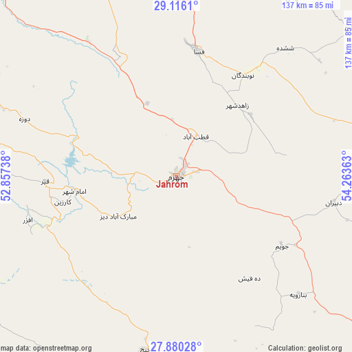
Jahrom GPS coordinates[2]
28° 30' 0" North, 53° 33' 37.8" East
| Map corner | latitude | longitude |
|---|---|---|
| Upper-left | 29.1161°, | 52.85738° |
| Center: | 28.5°, | 53.5605° |
| Lower-right: | 27.88028°, | 54.26363° |
| Map W x H: | 137.4×137.4 km | = 85.4×85.4mi |
| max Lat: | 39.6482° ⇑90.7% North |
| Jahrom: | 28.5° |
| min Lat: | ⇓9.3% South 25.2919° |
| min Long | Jahrom | max Long |
| 44.38416° | 53.5605° | 61.9965° |
| W 69.6%⇐ | ⇒30.4% E |
Elevation
Elevation of Jahrom is 1040 m = 3412 ft, and this is 9 m = 30 ft below average elevation for this country.
| Max E: |
2564 m = 8412 ft | 56.7% |
| Avg. | 1049 m = 3442 ft | |
| Jahrom | 1040 m = 3412 ft | |
Min E: |
-24 m = -79 ft | 43.3% |
See also: Iran elevation on elevation.city.
Geographical zone
Jahrom is located in North temperate zone (between Tropic of Cancer and the Arctic Circle). Distance of this Northern Tropic circle is 563 km =349.8 mi to South.| Distance of | km | miles | from Jahrom |
|---|---|---|---|
| North Pole | 6838.2 | 4249.1 | to North |
| Arctic Circle | 4232.3 | 2629.8 | to North |
| Tropic Cancer | 563 | 349.8 | to South |
| Equator | 3168.9 | 1969.1 | to South |


Nearby cities:
15 places around Jahrom: (largest is in red/bold)
• Akbarābād
112.6 km =70 mi,  317°
317°
• Dārāb
100 km =62.1 mi,  73°
73°
• Estahbān
84 km =52.2 mi,  33°
33°
• Fasā
49.5 km =30.8 mi,  9°
9°
• Fīrūzābād
103.9 km =64.6 mi,  291°
291°
• Gerāsh
108.2 km =67.2 mi,  148°
148°
• Kavār
115.5 km =71.8 mi,  312°
312°
• Kherāmeh
113.7 km =70.6 mi,  347°
347°
• Khonj
68.8 km =42.8 mi,  190°
190°
• Mohr
124.3 km =77.2 mi,  212°
212°
• Neyrīz
107.8 km =67 mi,  43°
43°
• Qīr
51.4 km =31.9 mi,  267°
267°
• Sarvestān
92.2 km =57.3 mi,  338°
338°
• Shahr-e Qadīm-e Lār
118.8 km =73.8 mi,  139°
139°
• Ḩājjīābād
85.8 km =53.3 mi,  100°
100°
Sources, notices
• [Note1] Compared only with cities in Iran existing in our database
• [Src1] Map data: © OpenStreetMap contributors (CC-BY-SA)
• [Src2] Other city data from geonames.org with taken over terms of usage.
• [Src3] Geographical zone / Annual Mean Temperature by Robert A. Rohde @ Wikipedia
