Fasā geodata
Fasā (Fars) is a seat of a second-order administrative division; located in Iran in Asia/Tehran (GMT+3.5) time zone. With population of 98,061 people, there are 69 cities with bigger population in this country. Compared to other cities in Iran, 88.9% of cities are located further ↑North; 69.8% of cities are located further ←West and 63% of cities have lower elevation than Fasā. Note1


Fasā GPS coordinates[2]
28° 56' 17.88" North, 53° 38' 53.52" East
| Map corner | latitude | longitude |
|---|---|---|
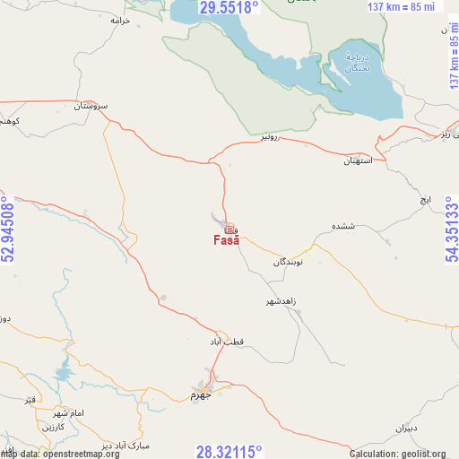
| Upper-left | 29.5518°, | 52.94508° |
| Center: | 28.9383°, | 53.6482° |
| Lower-right: | 28.32115°, | 54.35133° |
| Map W x H: | 136.8×136.8 km | = 85×85mi |
| max Lat: | 39.6482° ⇑88.9% North |
| Fasā: | 28.9383° |
| min Lat: | ⇓11.1% South 25.2919° |
| min Long | Fasā | max Long |
| 44.38416° | 53.6482° | 61.9965° |
| W 69.8%⇐ | ⇒30.2% E |
Elevation
Elevation of Fasā is 1366 m = 4482 ft, and this is 317 m = 1040 ft above average elevation for this country.
| Max E: |
2564 m = 8412 ft | 37% |
| Fasā | 1366 m 4482 ft | |
| Avg. | 1049 m = 3442 ft | |
Min E: |
-24 m = -79 ft | 63% |
See also: Fasā elevation on elevation.city.
Geographical zone
Fasā is located in North temperate zone (between Tropic of Cancer and the Arctic Circle). Distance of this Northern Tropic circle is 611.7 km =380.1 mi to South.| Distance of | km | miles | from Fasā |
|---|---|---|---|
| North Pole | 6789.4 | 4218.7 | to North |
| Arctic Circle | 4183.5 | 2599.5 | to North |
| Tropic Cancer | 611.7 | 380.1 | to South |
| Equator | 3217.6 | 1999.3 | to South |


Nearby cities:
15 places around Fasā: (largest is in red/bold)
• Akbarābād
91.1 km =56.6 mi,  292°
292°
• Arsanjān
113.2 km =70.3 mi,  343°
343°
• Dārāb
89.7 km =55.7 mi,  103°
103°
• Estahbān
43.6 km =27.1 mi,  61°
61°
• Fīrūzābād
105.4 km =65.5 mi,  264°
264°
• Jahrom
49.5 km =30.8 mi,  189°
189°
• Kavār
97.7 km =60.7 mi, 287°
• Kherāmeh
70.4 km =43.7 mi,  332°
332°
• Khonj
118.3 km =73.5 mi, 190°
• Marvdasht
132.4 km =82.3 mi,  321°
321°
• Neyrīz
72.1 km =44.8 mi,  66°
66°
• Qīr
78.4 km =48.7 mi,  229°
229°
• Sarvestān
55.8 km =34.7 mi,  311°
311°
• Shiraz
131.6 km =81.8 mi,  304°
304°
• Ḩājjīābād
99.5 km =61.8 mi,  130°
130°
Sources, notices
• [Note1] Compared only with cities in Iran existing in our database
• [Src1] Map data: © OpenStreetMap contributors (CC-BY-SA)
• [Src2] Other city data from geonames.org with taken over terms of usage.
• [Src3] Geographical zone / Annual Mean Temperature by Robert A. Rohde @ Wikipedia
