Neyrīz geodata
Neyrīz (Fars) is a seat of a second-order administrative division; located in Iran in Asia/Tehran (GMT+3.5) time zone. With population of 45,506 people, there are 143 cities with bigger population in this country. Compared to other cities in Iran, 87.5% of cities are located further ↑North; 73.2% of cities are located further ←West and 77.3% of cities have lower elevation than Neyrīz. Note1


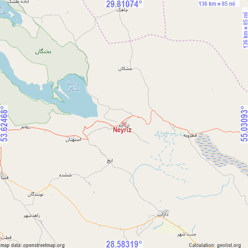
Neyrīz GPS coordinates[2]
29° 11' 55.68" North, 54° 19' 40.08" East
| Map corner | latitude | longitude |
|---|---|---|
| Upper-left | 29.81074°, | 53.62468° |
| Center: | 29.1988°, | 54.3278° |
| Lower-right: | 28.58319°, | 55.03093° |
| Map W x H: | 136.5×136.5 km | = 84.8×84.8mi |
| max Lat: | 39.6482° ⇑87.5% North |
| Neyrīz: | 29.1988° |
| min Lat: | ⇓12.5% South 25.2919° |
| min Long | Neyrīz | max Long |
| 44.38416° | 54.3278° | 61.9965° |
| W 73.2%⇐ | ⇒26.8% E |
Elevation
Elevation of Neyrīz is 1606 m = 5269 ft, and this is 557 m = 1827 ft above average elevation for this country.
| Max E: |
2564 m = 8412 ft | 22.7% |
| Neyrīz | 1606 m 5269 ft | |
| Avg. | 1049 m = 3442 ft | |
Min E: |
-24 m = -79 ft | 77.3% |
See also: Neyrīz elevation on elevation.city.
Geographical zone
Neyrīz is located in North temperate zone (between Tropic of Cancer and the Arctic Circle). Distance of this Northern Tropic circle is 640.7 km =398.1 mi to South.| Distance of | km | miles | from Neyrīz |
|---|---|---|---|
| North Pole | 6760.5 | 4200.8 | to North |
| Arctic Circle | 4154.6 | 2581.5 | to North |
| Tropic Cancer | 640.7 | 398.1 | to South |
| Equator | 3246.6 | 2017.3 | to South |


Nearby cities:
15 places around Neyrīz: (largest is in red/bold)
• Akbarābād
150.4 km =93.5 mi,  272°
272°
• Arsanjān
126.5 km =78.6 mi,  308°
308°
• Dārāb
54 km =33.6 mi,  157°
157°
• Estahbān
28.9 km =18 mi,  253°
253°
• Fasā
72.1 km =44.8 mi, 246°
• Jahrom
107.8 km =67 mi,  223°
223°
• Kherāmeh
104 km =64.6 mi,  288°
288°
• Qīr
149 km =92.6 mi,  237°
237°
• Sarvestān
107.8 km =67 mi, 274°
• Sa‘ādat Shahr
151.3 km =94 mi, 310°
• Shahr-e Bābak
127.5 km =79.2 mi,  36°
36°
• Shahr-e Herāt
95.2 km =59.2 mi,  2°
2°
• Sirjan
134.1 km =83.3 mi,  77°
77°
• Sūrīān
154.2 km =95.8 mi,  334°
334°
• Ḩājjīābād
94 km =58.4 mi,  174°
174°
Sources, notices
• [Note1] Compared only with cities in Iran existing in our database
• [Src1] Map data: © OpenStreetMap contributors (CC-BY-SA)
• [Src2] Other city data from geonames.org with taken over terms of usage.
• [Src3] Geographical zone / Annual Mean Temperature by Robert A. Rohde @ Wikipedia
