Asadīyeh geodata
Asadīyeh (Khorāsān-e Jonūbī) is a seat of a second-order administrative division; located in Iran in Asia/Tehran (GMT+3.5) time zone. In our database, there are 232 cities with bigger population. Compared to other cities in Iran, 61.2% of cities are located further ↑North; 94.6% of cities are located further ←West and 96.6% of cities have lower elevation than Asadīyeh. Note1


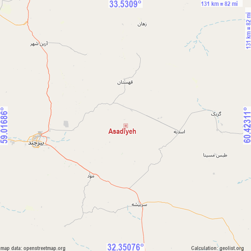
Asadīyeh GPS coordinates[2]
32° 56' 34.08" North, 59° 43' 11.928" East
| Map corner | latitude | longitude |
|---|---|---|
| Upper-left | 33.5309°, | 59.01686° |
| Center: | 32.9428°, | 59.71998° |
| Lower-right: | 32.35076°, | 60.42311° |
| Map W x H: | 131.2×131.2 km | = 81.5×81.5mi |
| max Lat: | 39.6482° ⇑61.2% North |
| Asadīyeh: | 32.9428° |
| min Lat: | ⇓38.8% South 25.2919° |
| min Long | Asadīyeh | max Long |
| 44.38416° | 59.71998° | 61.9965° |
| W 94.6%⇐ | ⇒5.4% E |
Elevation
Elevation of Asadīyeh is 2170 m = 7119 ft, and this is 1121 m = 3678 ft above average elevation for this country.
| Max E: |
2564 m = 8412 ft | 3.4% |
| Asadīyeh | 2170 m 7119 ft | |
| Avg. | 1049 m = 3442 ft | |
Min E: |
-24 m = -79 ft | 96.6% |
See also: Iran elevation on elevation.city.
Geographical zone
Asadīyeh is located in North temperate zone (between Tropic of Cancer and the Arctic Circle). Distance of this Northern Tropic circle is 1057 km =656.8 mi to South.| Distance of | km | miles | from Asadīyeh |
|---|---|---|---|
| North Pole | 6344.2 | 3942.1 | to North |
| Arctic Circle | 3738.3 | 2322.9 | to North |
| Tropic Cancer | 1057 | 656.8 | to South |
| Equator | 3662.9 | 2276 | to South |


Nearby cities:
15 places around Asadīyeh: (largest is in red/bold)
• Bajestān
225.3 km =140 mi,  320°
320°
• Boshrūyeh
236.3 km =146.8 mi,  295°
295°
• Bīrjand
47.3 km =29.4 mi,  259°
259°
• Ferdows
186.8 km =116.1 mi,  309°
309°
• Feyẕābād
246.5 km =153.2 mi,  339°
339°
• Gonābād
183.8 km =114.2 mi,  328°
328°
• Khvāf
185.7 km =115.4 mi,  12°
12°
• Nehbandān
158.6 km =98.5 mi,  169°
169°
• Qā’en
100.3 km =62.3 mi, 330°
• Roshtkhvār
226.1 km =140.5 mi,  357°
357°
• Sarbīsheh
41.5 km =25.8 mi, 169°
• Sarāyān
150.9 km =93.8 mi, 312°
• Shahrak-e Bākharz
234.4 km =145.6 mi, 13°
• Tāybād
222.3 km =138.1 mi,  26°
26°
• Ḩājjīābād
77.9 km =48.4 mi,  19°
19°
Sources, notices
• [Note1] Compared only with cities in Iran existing in our database
• [Src1] Map data: © OpenStreetMap contributors (CC-BY-SA)
• [Src2] Other city data from geonames.org with taken over terms of usage.
• [Src3] Geographical zone / Annual Mean Temperature by Robert A. Rohde @ Wikipedia
