Bījār geodata
Bījār (Kordestān) is a populated place; located in Iran in Asia/Tehran (GMT+3.5) time zone. With population of 53,871 people, there are 116 cities with bigger population in this country. Compared to other cities in Iran, 67.6% of cities are located further ↓South; 84.8% of cities are located further →East and 92.1% of cities have lower elevation than Bījār. Note1


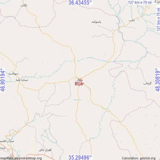
Bījār GPS coordinates[2]
35° 52' 0.48" North, 47° 36' 18.216" East
| Map corner | latitude | longitude |
|---|---|---|
| Upper-left | 36.43455°, | 46.90194° |
| Center: | 35.8668°, | 47.60506° |
| Lower-right: | 35.29496°, | 48.30819° |
| Map W x H: | 126.7×126.7 km | = 78.7×78.7mi |
| max Lat: | 39.6482° ⇑32.4% North |
| Bījār: | 35.8668° |
| min Lat: | ⇓67.6% South 25.2919° |
| min Long | Bījār | max Long |
| 44.38416° | 47.60506° | 61.9965° |
| W 15.2%⇐ | ⇒84.8% E |
Elevation
Elevation of Bījār is 1929 m = 6329 ft, and this is 880 m = 2887 ft above average elevation for this country.
| Max E: |
2564 m = 8412 ft | 7.9% |
| Bījār | 1929 m 6329 ft | |
| Avg. | 1049 m = 3442 ft | |
Min E: |
-24 m = -79 ft | 92.1% |
See also: Bījār elevation on elevation.city.
Geographical zone
Bījār is located in North temperate zone (between Tropic of Cancer and the Arctic Circle). Distance of this Northern Tropic circle is 1382.1 km =858.8 mi to South.| Distance of | km | miles | from Bījār |
|---|---|---|---|
| North Pole | 6019 | 3740 | to North |
| Arctic Circle | 3413.2 | 2120.9 | to North |
| Tropic Cancer | 1382.1 | 858.8 | to South |
| Equator | 3988 | 2478 | to South |


Nearby cities:
15 places around Bījār: (largest is in red/bold)
• Asadābād
129.3 km =80.3 mi,  158°
158°
• Dehgolān
67.6 km =42 mi,  194°
194°
• Dīvāndarreh
52.6 km =32.7 mi,  275°
275°
• Kabūdarāhang
124.8 km =77.5 mi,  125°
125°
• Māhneshān
97.8 km =60.8 mi,  3°
3°
• Qohūrd-e ‘Olyā
63.6 km =39.5 mi,  138°
138°
• Qorveh
80 km =49.7 mi,  166°
166°
• Sanandaj
82.3 km =51.1 mi,  221°
221°
• Saqqez
127 km =78.9 mi,  289°
289°
• Sarvābād
127.8 km =79.4 mi,  241°
241°
• Shāhīn Dezh
129.7 km =80.6 mi,  314°
314°
• Sonqor
120.6 km =74.9 mi,  180°
180°
• Takāb
74 km =46 mi,  323°
323°
• Zanjān
120.4 km =74.8 mi,  41°
41°
• Zarrīnābād
86.9 km =54 mi, 44°
Sources, notices
• [Note1] Compared only with cities in Iran existing in our database
• [Src1] Map data: © OpenStreetMap contributors (CC-BY-SA)
• [Src2] Other city data from geonames.org with taken over terms of usage.
• [Src3] Geographical zone / Annual Mean Temperature by Robert A. Rohde @ Wikipedia
