Qorveh geodata
Qorveh (Kordestān) is a seat of a second-order administrative division; located in Iran in Asia/Tehran (GMT+3.5) time zone. With population of 87,953 people, there are 79 cities with bigger population in this country. Compared to other cities in Iran, 57.4% of cities are located further ↓South; 83.2% of cities are located further →East and 91.4% of cities have lower elevation than Qorveh. Note1


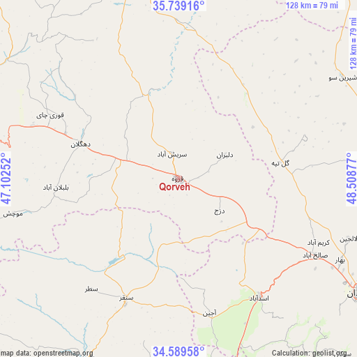
Qorveh GPS coordinates[2]
35° 9' 59.04" North, 47° 48' 20.304" East
| Map corner | latitude | longitude |
|---|---|---|
| Upper-left | 35.73916°, | 47.10252° |
| Center: | 35.1664°, | 47.80564° |
| Lower-right: | 34.58958°, | 48.50877° |
| Map W x H: | 127.8×127.8 km | = 79.4×79.4mi |
| max Lat: | 39.6482° ⇑42.6% North |
| Qorveh: | 35.1664° |
| min Lat: | ⇓57.4% South 25.2919° |
| min Long | Qorveh | max Long |
| 44.38416° | 47.80564° | 61.9965° |
| W 16.8%⇐ | ⇒83.2% E |
Elevation
Elevation of Qorveh is 1909 m = 6263 ft, and this is 860 m = 2822 ft above average elevation for this country.
| Max E: |
2564 m = 8412 ft | 8.6% |
| Qorveh | 1909 m 6263 ft | |
| Avg. | 1049 m = 3442 ft | |
Min E: |
-24 m = -79 ft | 91.4% |
See also: Qorveh elevation on elevation.city.
Geographical zone
Qorveh is located in North temperate zone (between Tropic of Cancer and the Arctic Circle). Distance of this Northern Tropic circle is 1304.2 km =810.4 mi to South.| Distance of | km | miles | from Qorveh |
|---|---|---|---|
| North Pole | 6096.9 | 3788.4 | to North |
| Arctic Circle | 3491 | 2169.2 | to North |
| Tropic Cancer | 1304.2 | 810.4 | to South |
| Equator | 3910.1 | 2429.6 | to South |


Nearby cities:
15 places around Qorveh: (largest is in red/bold)
• Asadābād
51.4 km =31.9 mi,  146°
146°
• Bahār
64.7 km =40.2 mi,  116°
116°
• Bījār
80 km =49.7 mi,  346°
346°
• Dehgolān
37.3 km =23.2 mi,  289°
289°
• Hamadān
76.4 km =47.5 mi, 122°
• Kabūdarāhang
83.5 km =51.9 mi,  86°
86°
• Kangāvar
75 km =46.6 mi,  168°
168°
• Kāmyārān
89.4 km =55.6 mi,  242°
242°
• Pasragad Branch
74.5 km =46.3 mi,  125°
125°
• Qohūrd-e ‘Olyā
38.9 km =24.2 mi,  38°
38°
• Sanandaj
75.1 km =46.7 mi,  282°
282°
• Sonqor
46.7 km =29 mi,  203°
203°
• Tūyserkān
89.8 km =55.8 mi,  139°
139°
• Āzādshahr
81.2 km =50.5 mi, 120°
• Şaḩneh
76.9 km =47.8 mi,  187°
187°
Sources, notices
• [Note1] Compared only with cities in Iran existing in our database
• [Src1] Map data: © OpenStreetMap contributors (CC-BY-SA)
• [Src2] Other city data from geonames.org with taken over terms of usage.
• [Src3] Geographical zone / Annual Mean Temperature by Robert A. Rohde @ Wikipedia
