Qohūrd-e ‘Olyā geodata
Qohūrd-e ‘Olyā (Hamadān) is a populated place; located in Iran in Asia/Tehran (GMT+3.5) time zone. With population of 2,115 people, there are 218 cities with bigger population in this country. Compared to other cities in Iran, 62.1% of cities are located further ↓South; 81.6% of cities are located further →East and 92.3% of cities have lower elevation than Qohūrd-e ‘Olyā. Note1


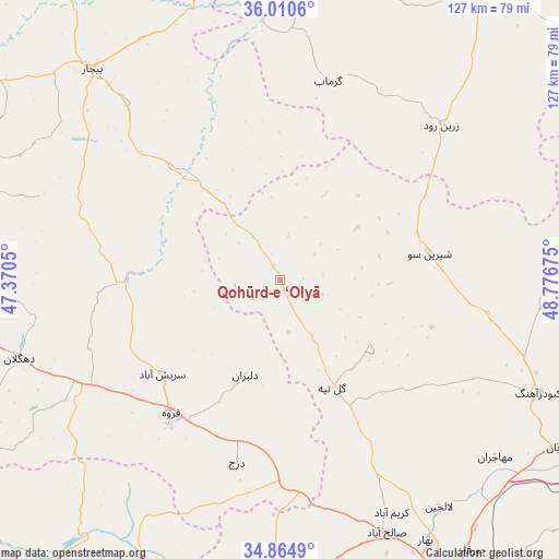
Qohūrd-e ‘Olyā GPS coordinates[2]
35° 26' 23.244" North, 48° 4' 25.032" East
| Map corner | latitude | longitude |
|---|---|---|
| Upper-left | 36.0106°, | 47.3705° |
| Center: | 35.43979°, | 48.07362° |
| Lower-right: | 34.8649°, | 48.77675° |
| Map W x H: | 127.4×127.4 km | = 79.2×79.2mi |
| max Lat: | 39.6482° ⇑37.9% North |
| Qohūrd-e ‘Olyā: | 35.43979° |
| min Lat: | ⇓62.1% South 25.2919° |
| min Long | Qohūrd-e ‘Ol | max Long |
| 44.38416° | 48.07362° | 61.9965° |
| W 18.4%⇐ | ⇒81.6% E |
Elevation
Elevation of Qohūrd-e ‘Olyā is 1933 m = 6342 ft, and this is 884 m = 2900 ft above average elevation for this country.
| Max E: |
2564 m = 8412 ft | 7.7% |
| Qohūrd-e ‘Olyā | 1933 m 6342 ft | |
| Avg. | 1049 m = 3442 ft | |
Min E: |
-24 m = -79 ft | 92.3% |
See also: Iran elevation on elevation.city.
Geographical zone
Qohūrd-e ‘Olyā is located in North temperate zone (between Tropic of Cancer and the Arctic Circle). Distance of this Northern Tropic circle is 1334.6 km =829.3 mi to South.| Distance of | km | miles | from Qohūrd-e ‘Olyā |
|---|---|---|---|
| North Pole | 6066.5 | 3769.5 | to North |
| Arctic Circle | 3460.6 | 2150.3 | to North |
| Tropic Cancer | 1334.6 | 829.3 | to South |
| Equator | 3940.5 | 2448.5 | to South |


Nearby cities:
15 places around Qohūrd-e ‘Olyā: (largest is in red/bold)
• Asadābād
73.2 km =45.5 mi,  176°
176°
• Bahār
68 km =42.3 mi,  150°
150°
• Bījār
63.6 km =39.5 mi,  318°
318°
• Dehgolān
62.1 km =38.6 mi,  253°
253°
• Fāmenīn
89.3 km =55.5 mi,  113°
113°
• Hamadān
81.7 km =50.8 mi, 150°
• Kabūdarāhang
64.3 km =40 mi, 113°
• Kangāvar
104.5 km =64.9 mi,  185°
185°
• Pasragad Branch
82 km =51 mi, 153°
• Qorveh
38.9 km =24.2 mi,  218°
218°
• Razan
87.2 km =54.2 mi,  93°
93°
• Sanandaj
98.4 km =61.1 mi,  261°
261°
• Sonqor
84.9 km =52.8 mi,  210°
210°
• Tūyserkān
104.4 km =64.9 mi,  161°
161°
• Āzādshahr
85.2 km =52.9 mi, 147°
Sources, notices
• [Note1] Compared only with cities in Iran existing in our database
• [Src1] Map data: © OpenStreetMap contributors (CC-BY-SA)
• [Src2] Other city data from geonames.org with taken over terms of usage.
• [Src3] Geographical zone / Annual Mean Temperature by Robert A. Rohde @ Wikipedia
