Shahrak-e Bākharz geodata
Shahrak-e Bākharz (Razavi Khorasan) is a seat of a second-order administrative division; located in Iran in Asia/Tehran (GMT+3.5) time zone. In our database, there are 232 cities with bigger population. Compared to other cities in Iran, 56.2% of cities are located further ↓South; 96.6% of cities are located further ←West and 56% of cities have lower elevation than Shahrak-e Bākharz. Note1


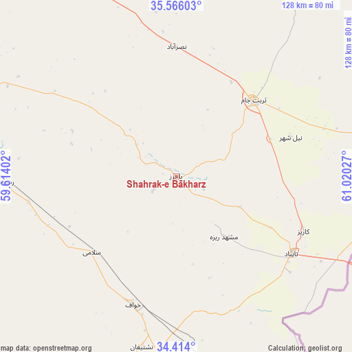
Shahrak-e Bākharz GPS coordinates[2]
34° 59' 31.344" North, 60° 19' 1.704" East
| Map corner | latitude | longitude |
|---|---|---|
| Upper-left | 35.56603°, | 59.61402° |
| Center: | 34.99204°, | 60.31714° |
| Lower-right: | 34.414°, | 61.02027° |
| Map W x H: | 128.1×128.1 km | = 79.6×79.6mi |
| max Lat: | 39.6482° ⇑43.8% North |
| Shahrak-e Bākharz: | 34.99204° |
| min Lat: | ⇓56.2% South 25.2919° |
| min Long | Shahrak-e Bākh | max Long |
| 44.38416° | 60.31714° | 61.9965° |
| W 96.6%⇐ | ⇒3.4% E |
Elevation
Elevation of Shahrak-e Bākharz is 1276 m = 4186 ft, and this is 227 m = 745 ft above average elevation for this country.
| Max E: |
2564 m = 8412 ft | 44% |
| Shahrak-e Bākharz | 1276 m 4186 ft | |
| Avg. | 1049 m = 3442 ft | |
Min E: |
-24 m = -79 ft | 56% |
See also: Iran elevation on elevation.city.
Geographical zone
Shahrak-e Bākharz is located in North temperate zone (between Tropic of Cancer and the Arctic Circle). Distance of this Northern Tropic circle is 1284.8 km =798.3 mi to South.| Distance of | km | miles | from Shahrak-e Bākharz |
|---|---|---|---|
| North Pole | 6116.3 | 3800.5 | to North |
| Arctic Circle | 3510.4 | 2181.3 | to North |
| Tropic Cancer | 1284.8 | 798.3 | to South |
| Equator | 3890.8 | 2417.6 | to South |


Nearby cities:
15 places around Shahrak-e Bākharz: (largest is in red/bold)
• Dowlatābād
79.4 km =49.3 mi,  293°
293°
• Farīmān
90.1 km =56 mi,  331°
331°
• Feyẕābād
139.7 km =86.8 mi,  271°
271°
• Gonābād
165.4 km =102.8 mi,  244°
244°
• Khalīlābād
187 km =116.2 mi,  278°
278°
• Khvāf
48.9 km =30.4 mi,  199°
199°
• Kāshmar
170.6 km =106 mi, 279°
• Mashhad
162 km =100.7 mi,  335°
335°
• Qā’en
175 km =108.7 mi,  216°
216°
• Roshtkhvār
63.1 km =39.2 mi, 268°
• Torbat-e Jām
39.4 km =24.5 mi,  44°
44°
• Torbat-e Ḩeydarīyeh
104.6 km =65 mi, 287°
• Tāybād
50.3 km =31.3 mi,  123°
123°
• Ţorqabeh
169.6 km =105.4 mi, 329°
• Ḩājjīābād
157.1 km =97.6 mi,  190°
190°
Sources, notices
• [Note1] Compared only with cities in Iran existing in our database
• [Src1] Map data: © OpenStreetMap contributors (CC-BY-SA)
• [Src2] Other city data from geonames.org with taken over terms of usage.
• [Src3] Geographical zone / Annual Mean Temperature by Robert A. Rohde @ Wikipedia
