Ahram geodata
Ahram (Bushehr) is a seat of a second-order administrative division; located in Iran in Asia/Tehran (GMT+3.5) time zone. In our database, there are 232 cities with bigger population. Compared to other cities in Iran, 89.1% of cities are located further ↑North; 50.6% of cities are located further →East and 83% of cities have higher elevation than Ahram. Note1


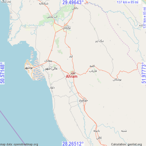
Ahram GPS coordinates[2]
28° 52' 57.36" North, 51° 16' 28.56" East
| Map corner | latitude | longitude |
|---|---|---|
| Upper-left | 29.49643°, | 50.57148° |
| Center: | 28.8826°, | 51.2746° |
| Lower-right: | 28.26512°, | 51.97773° |
| Map W x H: | 136.9×136.9 km | = 85.1×85.1mi |
| max Lat: | 39.6482° ⇑89.1% North |
| Ahram: | 28.8826° |
| min Lat: | ⇓10.9% South 25.2919° |
| min Long | Ahram | max Long |
| 44.38416° | 51.2746° | 61.9965° |
| W 49.4%⇐ | ⇒50.6% E |
Elevation
Elevation of Ahram is 63 m = 207 ft, and this is 986 m = 3235 ft below average elevation for this country.
| Max E: |
2564 m = 8412 ft | 83% |
| Avg. | 1049 m = 3442 ft | |
| Ahram | 63 m = 207 ft | |
Min E: |
-24 m = -79 ft | 17% |
See also: Iran elevation on elevation.city.
Geographical zone
Ahram is located in North temperate zone (between Tropic of Cancer and the Arctic Circle). Distance of this Northern Tropic circle is 605.5 km =376.2 mi to South.| Distance of | km | miles | from Ahram |
|---|---|---|---|
| North Pole | 6795.6 | 4222.6 | to North |
| Arctic Circle | 4189.7 | 2603.4 | to North |
| Tropic Cancer | 605.5 | 376.2 | to South |
| Equator | 3211.4 | 1995.5 | to South |


Nearby cities:
15 places around Ahram: (largest is in red/bold)
• Akbarābād
151.7 km =94.3 mi,  74°
74°
• Bandar-e Genāveh
106.8 km =66.4 mi,  316°
316°
• Borāzjān
43.4 km =27 mi,  352°
352°
• Bushehr
43.7 km =27.2 mi,  282°
282°
• Deyr
132.9 km =82.6 mi,  150°
150°
• Farāshband
79.6 km =49.5 mi,  90°
90°
• Fīrūzābād
126.3 km =78.5 mi, 91°
• Kangān
139.8 km =86.9 mi, 146°
• Kavār
142.2 km =88.4 mi,  75°
75°
• Khowrmūj
27.4 km =17 mi,  157°
157°
• Khārk
100.9 km =62.7 mi,  294°
294°
• Kāzerūn
89.8 km =55.8 mi,  24°
24°
• Maşīrī
153.5 km =95.4 mi,  8°
8°
• Nūrābād
139 km =86.4 mi, 9°
• Shiraz
146.3 km =90.9 mi,  56°
56°
Sources, notices
• [Note1] Compared only with cities in Iran existing in our database
• [Src1] Map data: © OpenStreetMap contributors (CC-BY-SA)
• [Src2] Other city data from geonames.org with taken over terms of usage.
• [Src3] Geographical zone / Annual Mean Temperature by Robert A. Rohde @ Wikipedia
