Anār geodata
Anār (Kerman) is a seat of a second-order administrative division; located in Iran in Asia/Tehran (GMT+3.5) time zone. In our database, there are 232 cities with bigger population. Compared to other cities in Iran, 77.1% of cities are located further ↑North; 78% of cities are located further ←West and 65.5% of cities have lower elevation than Anār. Note1


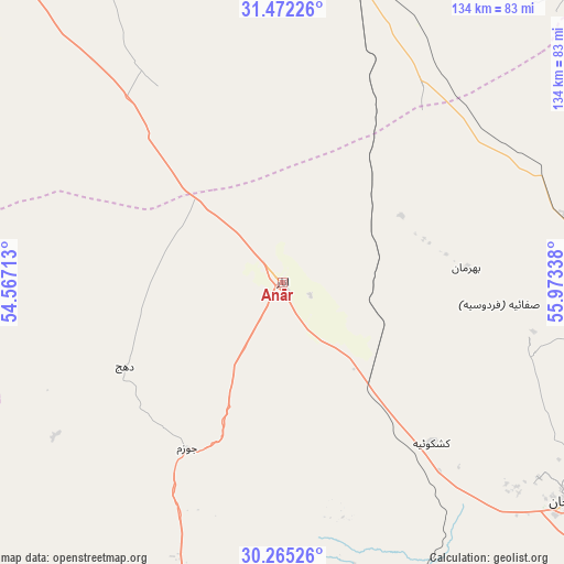
Anār GPS coordinates[2]
30° 52' 14.376" North, 55° 16' 12.9" East
| Map corner | latitude | longitude |
|---|---|---|
| Upper-left | 31.47226°, | 54.56713° |
| Center: | 30.87066°, | 55.27025° |
| Lower-right: | 30.26526°, | 55.97338° |
| Map W x H: | 134.2×134.2 km | = 83.4×83.4mi |
| max Lat: | 39.6482° ⇑77.1% North |
| Anār: | 30.87066° |
| min Lat: | ⇓22.9% South 25.2919° |
| min Long | Anār | max Long |
| 44.38416° | 55.27025° | 61.9965° |
| W 78%⇐ | ⇒22% E |
Elevation
Elevation of Anār is 1409 m = 4623 ft, and this is 360 m = 1181 ft above average elevation for this country.
| Max E: |
2564 m = 8412 ft | 34.5% |
| Anār | 1409 m 4623 ft | |
| Avg. | 1049 m = 3442 ft | |
Min E: |
-24 m = -79 ft | 65.5% |
See also: Iran elevation on elevation.city.
Geographical zone
Anār is located in North temperate zone (between Tropic of Cancer and the Arctic Circle). Distance of this Northern Tropic circle is 826.6 km =513.6 mi to South.| Distance of | km | miles | from Anār |
|---|---|---|---|
| North Pole | 6574.6 | 4085.3 | to North |
| Arctic Circle | 3968.7 | 2466 | to North |
| Tropic Cancer | 826.6 | 513.6 | to South |
| Equator | 3432.5 | 2132.9 | to South |


Nearby cities:
15 places around Anār: (largest is in red/bold)
• Bahābād
132.3 km =82.2 mi,  32°
32°
• Bāfq
82.4 km =51.2 mi,  8°
8°
• Kūhbanān
113.5 km =70.5 mi,  58°
58°
• Mahrīz
111.7 km =69.4 mi,  315°
315°
• Rafsanjān
86.3 km =53.6 mi,  126°
126°
• Rāvar
152.7 km =94.9 mi,  73°
73°
• Shahr-e Bābak
85.1 km =52.9 mi,  189°
189°
• Shahr-e Herāt
125.1 km =77.7 mi,  223°
223°
• Shahrak-e Pābedānā
111.4 km =69.2 mi, 74°
• Sirjan
162.7 km =101.1 mi,  165°
165°
• Sūrīān
161.6 km =100.4 mi,  253°
253°
• Taft
140.3 km =87.2 mi,  314°
314°
• Taft
140.4 km =87.2 mi, 313°
• Yazd
142.7 km =88.7 mi, 323°
• Zarand
123.7 km =76.9 mi,  92°
92°
Sources, notices
• [Note1] Compared only with cities in Iran existing in our database
• [Src1] Map data: © OpenStreetMap contributors (CC-BY-SA)
• [Src2] Other city data from geonames.org with taken over terms of usage.
• [Src3] Geographical zone / Annual Mean Temperature by Robert A. Rohde @ Wikipedia
