Sarakhs geodata
Sarakhs (Razavi Khorasan) is a seat of a second-order administrative division; located in Iran in Asia/Tehran (GMT+3.5) time zone. With population of 46,499 people, there are 141 cities with bigger population in this country. Compared to other cities in Iran, 74.4% of cities are located further ↓South; 98.4% of cities are located further ←West and 77.6% of cities have higher elevation than Sarakhs. Note1


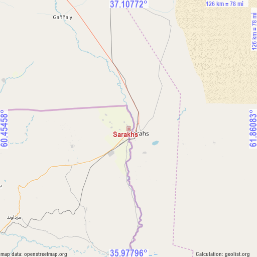
Sarakhs GPS coordinates[2]
36° 32' 41.64" North, 61° 9' 27.72" East
| Map corner | latitude | longitude |
|---|---|---|
| Upper-left | 37.10772°, | 60.45458° |
| Center: | 36.5449°, | 61.1577° |
| Lower-right: | 35.97796°, | 61.86083° |
| Map W x H: | 125.6×125.6 km | = 78×78mi |
| max Lat: | 39.6482° ⇑25.6% North |
| Sarakhs: | 36.5449° |
| min Lat: | ⇓74.4% South 25.2919° |
| min Long | Sarakhs | max Long |
| 44.38416° | 61.1577° | 61.9965° |
| W 98.4%⇐ | ⇒1.6% E |
Elevation
Elevation of Sarakhs is 276 m = 906 ft, and this is 773 m = 2536 ft below average elevation for this country.
| Max E: |
2564 m = 8412 ft | 77.6% |
| Avg. | 1049 m = 3442 ft | |
| Sarakhs | 276 m = 906 ft | |
Min E: |
-24 m = -79 ft | 22.4% |
See also: Sarakhs elevation on elevation.city.
Geographical zone
Sarakhs is located in North temperate zone (between Tropic of Cancer and the Arctic Circle). Distance of this Northern Tropic circle is 1457.5 km =905.6 mi to South.| Distance of | km | miles | from Sarakhs |
|---|---|---|---|
| North Pole | 5943.6 | 3693.2 | to North |
| Arctic Circle | 3337.8 | 2074 | to North |
| Tropic Cancer | 1457.5 | 905.6 | to South |
| Equator | 4063.4 | 2524.9 | to South |


Nearby cities:
15 places around Sarakhs: (largest is in red/bold)
• Bozghān
231.9 km =144.1 mi,  262°
262°
• Chenārān
182.1 km =113.2 mi,  273°
273°
• Dargaz
207.7 km =129.1 mi,  298°
298°
• Dowlatābād
203.6 km =126.5 mi,  226°
226°
• Farīmān
149.9 km =93.1 mi, 231°
• Kalāt-e Nāderī
133.8 km =83.1 mi,  291°
291°
• Khvāf
237.4 km =147.5 mi,  202°
202°
• Mashhad
144.5 km =89.8 mi, 259°
• Neyshābūr
214.6 km =133.3 mi, 260°
• Roshtkhvār
222.7 km =138.4 mi,  218°
218°
• Shahrak-e Bākharz
188.6 km =117.2 mi, 203°
• Torbat-e Jām
152.5 km =94.8 mi, 198°
• Torbat-e Ḩeydarīyeh
224.6 km =139.6 mi, 231°
• Tāybād
203.6 km =126.5 mi,  189°
189°
• Ţorqabeh
161.7 km =100.5 mi, 260°
Sources, notices
• [Note1] Compared only with cities in Iran existing in our database
• [Src1] Map data: © OpenStreetMap contributors (CC-BY-SA)
• [Src2] Other city data from geonames.org with taken over terms of usage.
• [Src3] Geographical zone / Annual Mean Temperature by Robert A. Rohde @ Wikipedia
