Khowrmūj geodata
Khowrmūj (Bushehr) is a seat of a second-order administrative division; located in Iran in Asia/Tehran (GMT+3.5) time zone. In our database, there are 232 cities with bigger population. Compared to other cities in Iran, 90.5% of cities are located further ↑North; 50.6% of cities are located further ←West and 83.9% of cities have higher elevation than Khowrmūj. Note1


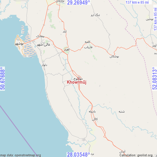
Khowrmūj GPS coordinates[2]
28° 39' 15.48" North, 51° 22' 48" East
| Map corner | latitude | longitude |
|---|---|---|
| Upper-left | 29.26949°, | 50.67688° |
| Center: | 28.6543°, | 51.38° |
| Lower-right: | 28.03548°, | 52.08313° |
| Map W x H: | 137.2×137.2 km | = 85.3×85.3mi |
| max Lat: | 39.6482° ⇑90.5% North |
| Khowrmūj: | 28.6543° |
| min Lat: | ⇓9.5% South 25.2919° |
| min Long | Khowrmūj | max Long |
| 44.38416° | 51.38° | 61.9965° |
| W 50.6%⇐ | ⇒49.4% E |
Elevation
Elevation of Khowrmūj is 56 m = 184 ft, and this is 993 m = 3258 ft below average elevation for this country.
| Max E: |
2564 m = 8412 ft | 83.9% |
| Avg. | 1049 m = 3442 ft | |
| Khowrmūj | 56 m = 184 ft | |
Min E: |
-24 m = -79 ft | 16.1% |
See also: Iran elevation on elevation.city.
Geographical zone
Khowrmūj is located in North temperate zone (between Tropic of Cancer and the Arctic Circle). Distance of this Northern Tropic circle is 580.1 km =360.5 mi to South.| Distance of | km | miles | from Khowrmūj |
|---|---|---|---|
| North Pole | 6821 | 4238.4 | to North |
| Arctic Circle | 4215.1 | 2619.1 | to North |
| Tropic Cancer | 580.1 | 360.5 | to South |
| Equator | 3186.1 | 1979.8 | to South |


Nearby cities:
15 places around Khowrmūj: (largest is in red/bold)
• Ahram
27.4 km =17 mi,  337°
337°
• Akbarābād
151.2 km =94 mi,  64°
64°
• Bandar-e Genāveh
132.7 km =82.5 mi,  320°
320°
• Borāzjān
70.2 km =43.6 mi,  347°
347°
• Bushehr
63.5 km =39.5 mi,  303°
303°
• Deyr
105.8 km =65.7 mi,  148°
148°
• Farāshband
73.4 km =45.6 mi,  70°
70°
• Fīrūzābād
118 km =73.3 mi,  79°
79°
• Jam
130.4 km =81 mi,  134°
134°
• Kangān
113.1 km =70.3 mi,  143°
143°
• Kavār
141.4 km =87.9 mi, 64°
• Khārk
122.4 km =76.1 mi, 303°
• Kāzerūn
110.5 km =68.7 mi,  13°
13°
• Qīr
162.7 km =101.1 mi,  96°
96°
• Shiraz
154.3 km =95.9 mi,  46°
46°
Sources, notices
• [Note1] Compared only with cities in Iran existing in our database
• [Src1] Map data: © OpenStreetMap contributors (CC-BY-SA)
• [Src2] Other city data from geonames.org with taken over terms of usage.
• [Src3] Geographical zone / Annual Mean Temperature by Robert A. Rohde @ Wikipedia
