Bushehr geodata
Bushehr is a seat of a first-order administrative division; located in Iran in Asia/Tehran (GMT+3.5) time zone. With population of 165,377 people, there are 46 cities with bigger population in this country. Compared to other cities in Iran, 88.2% of cities are located further ↑North; 54.4% of cities are located further →East and 93% of cities have higher elevation than Bushehr. Note1


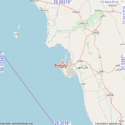
Bushehr GPS coordinates[2]
28° 58' 7.932" North, 50° 50' 11.652" East
| Map corner | latitude | longitude |
|---|---|---|
| Upper-left | 29.58219°, | 50.13345° |
| Center: | 28.96887°, | 50.83657° |
| Lower-right: | 28.3519°, | 51.5397° |
| Map W x H: | 136.8×136.8 km | = 85×85mi |
| max Lat: | 39.6482° ⇑88.2% North |
| Bushehr: | 28.96887° |
| min Lat: | ⇓11.8% South 25.2919° |
| min Long | Bushehr | max Long |
| 44.38416° | 50.83657° | 61.9965° |
| W 45.6%⇐ | ⇒54.4% E |
Elevation
Elevation of Bushehr is 8 m = 26 ft, and this is 1041 m = 3415 ft below average elevation for this country.
| Max E: |
2564 m = 8412 ft | 93% |
| Avg. | 1049 m = 3442 ft | |
| Bushehr | 8 m = 26 ft | |
Min E: |
-24 m = -79 ft | 7% |
See also: Bushehr elevation on elevation.city.
Geographical zone
Bushehr is located in North temperate zone (between Tropic of Cancer and the Arctic Circle). Distance of this Northern Tropic circle is 615.1 km =382.2 mi to South.| Distance of | km | miles | from Bushehr |
|---|---|---|---|
| North Pole | 6786 | 4216.6 | to North |
| Arctic Circle | 4180.1 | 2597.4 | to North |
| Tropic Cancer | 615.1 | 382.2 | to South |
| Equator | 3221 | 2001.4 | to South |


Nearby cities:
15 places around Bushehr: (largest is in red/bold)
• Ahram
43.7 km =27.2 mi,  102°
102°
• Bandar-e Deylam
137.3 km =85.3 mi,  331°
331°
• Bandar-e Genāveh
74.6 km =46.4 mi,  335°
335°
• Borāzjān
50 km =31.1 mi,  47°
47°
• Bāsht
157.9 km =98.1 mi,  11°
11°
• Deyr
165.4 km =102.8 mi,  139°
139°
• Dogonbadan
154.6 km =96.1 mi,  358°
358°
• Farāshband
122.6 km =76.2 mi, 95°
• Fīrūzābād
169.4 km =105.3 mi,  94°
94°
• Kangān
174.1 km =108.2 mi, 136°
• Khowrmūj
63.5 km =39.5 mi,  123°
123°
• Khārk
58.9 km =36.6 mi,  303°
303°
• Kāzerūn
107.3 km =66.7 mi, 47°
• Maşīrī
156.7 km =97.4 mi,  25°
25°
• Nūrābād
143.5 km =89.2 mi, 27°
Sources, notices
• [Note1] Compared only with cities in Iran existing in our database
• [Src1] Map data: © OpenStreetMap contributors (CC-BY-SA)
• [Src2] Other city data from geonames.org with taken over terms of usage.
• [Src3] Geographical zone / Annual Mean Temperature by Robert A. Rohde @ Wikipedia
