Kangān geodata
Kangān (Bushehr) is a seat of a second-order administrative division; located in Iran in Asia/Tehran (GMT+3.5) time zone. In our database, there are 232 cities with bigger population. Compared to other cities in Iran, 93.4% of cities are located further ↑North; 59.2% of cities are located further ←West and 90.9% of cities have higher elevation than Kangān. Note1


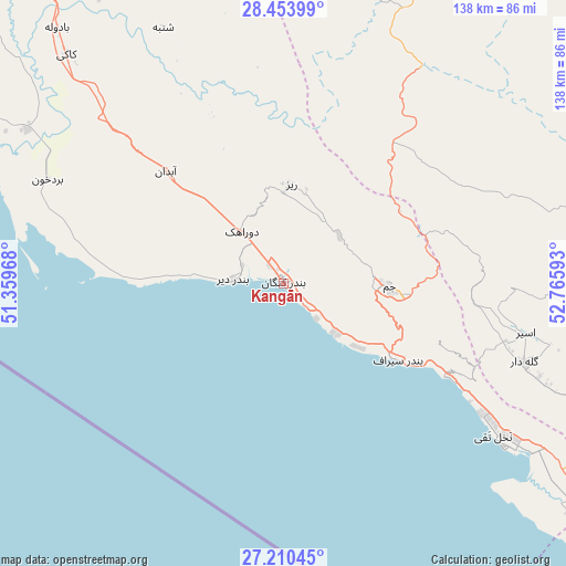
Kangān GPS coordinates[2]
27° 50' 2.4" North, 52° 3' 46.08" East
| Map corner | latitude | longitude |
|---|---|---|
| Upper-left | 28.45399°, | 51.35968° |
| Center: | 27.834°, | 52.0628° |
| Lower-right: | 27.21045°, | 52.76593° |
| Map W x H: | 138.3×138.3 km | = 85.9×85.9mi |
| max Lat: | 39.6482° ⇑93.4% North |
| Kangān: | 27.834° |
| min Lat: | ⇓6.6% South 25.2919° |
| min Long | Kangān | max Long |
| 44.38416° | 52.0628° | 61.9965° |
| W 59.2%⇐ | ⇒40.8% E |
Elevation
Elevation of Kangān is 11 m = 36 ft, and this is 1038 m = 3406 ft below average elevation for this country.
| Max E: |
2564 m = 8412 ft | 90.9% |
| Avg. | 1049 m = 3442 ft | |
| Kangān | 11 m = 36 ft | |
Min E: |
-24 m = -79 ft | 9.1% |
See also: Iran elevation on elevation.city.
Geographical zone
Kangān is located in North temperate zone (between Tropic of Cancer and the Arctic Circle). Distance of this Northern Tropic circle is 488.9 km =303.8 mi to South.| Distance of | km | miles | from Kangān |
|---|---|---|---|
| North Pole | 6912.2 | 4295 | to North |
| Arctic Circle | 4306.3 | 2675.8 | to North |
| Tropic Cancer | 488.9 | 303.8 | to South |
| Equator | 3094.9 | 1923.1 | to South |


Nearby cities:
15 places around Kangān: (largest is in red/bold)
• Ahram
139.8 km =86.9 mi,  326°
326°
• Akbarābād
171.9 km =106.8 mi,  24°
24°
• Bandar-e ‘Asalūyeh
66.8 km =41.5 mi,  126°
126°
• Deyr
12.3 km =7.6 mi,  273°
273°
• Farāshband
115.4 km =71.7 mi,  1°
1°
• Fīrūzābād
122.8 km =76.3 mi, 23°
• Gāvbandī
118.5 km =73.6 mi, 125°
• Jahrom
164.4 km =102.2 mi,  63°
63°
• Jam
25.8 km =16 mi,  91°
91°
• Kavār
164.3 km =102.1 mi, 21°
• Khonj
135 km =83.9 mi, 87°
• Khowrmūj
113.1 km =70.3 mi,  323°
323°
• Lamerd
123.3 km =76.6 mi,  116°
116°
• Mohr
86.6 km =53.8 mi,  110°
110°
• Qīr
119.5 km =74.3 mi,  52°
52°
Sources, notices
• [Note1] Compared only with cities in Iran existing in our database
• [Src1] Map data: © OpenStreetMap contributors (CC-BY-SA)
• [Src2] Other city data from geonames.org with taken over terms of usage.
• [Src3] Geographical zone / Annual Mean Temperature by Robert A. Rohde @ Wikipedia
