Asadābād geodata
Asadābād (Hamadān) is a seat of a second-order administrative division; located in Iran in Asia/Tehran (GMT+3.5) time zone. With population of 59,617 people, there are 107 cities with bigger population in this country. Compared to other cities in Iran, 54.4% of cities are located further ↓South; 81% of cities are located further →East and 76.6% of cities have lower elevation than Asadābād. Note1


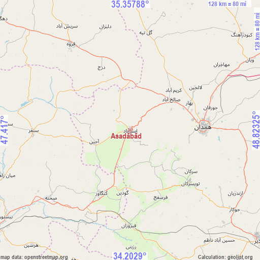
Asadābād GPS coordinates[2]
34° 46' 56.676" North, 48° 7' 12.432" East
| Map corner | latitude | longitude |
|---|---|---|
| Upper-left | 35.35788°, | 47.417° |
| Center: | 34.78241°, | 48.12012° |
| Lower-right: | 34.2029°, | 48.82325° |
| Map W x H: | 128.4×128.4 km | = 79.8×79.8mi |
| max Lat: | 39.6482° ⇑45.6% North |
| Asadābād: | 34.78241° |
| min Lat: | ⇓54.4% South 25.2919° |
| min Long | Asadābād | max Long |
| 44.38416° | 48.12012° | 61.9965° |
| W 19%⇐ | ⇒81% E |
Elevation
Elevation of Asadābād is 1596 m = 5236 ft, and this is 547 m = 1795 ft above average elevation for this country.
| Max E: |
2564 m = 8412 ft | 23.4% |
| Asadābād | 1596 m 5236 ft | |
| Avg. | 1049 m = 3442 ft | |
Min E: |
-24 m = -79 ft | 76.6% |
See also: Asadābād elevation on elevation.city.
Geographical zone
Asadābād is located in North temperate zone (between Tropic of Cancer and the Arctic Circle). Distance of this Northern Tropic circle is 1261.5 km =783.9 mi to South.| Distance of | km | miles | from Asadābād |
|---|---|---|---|
| North Pole | 6139.6 | 3815 | to North |
| Arctic Circle | 3533.7 | 2195.7 | to North |
| Tropic Cancer | 1261.5 | 783.9 | to South |
| Equator | 3867.4 | 2403.1 | to South |


Nearby cities:
15 places around Asadābād: (largest is in red/bold)
• Bahār
32.4 km =20.1 mi,  64°
64°
• Hamadān
36.1 km =22.4 mi,  87°
87°
• Harsīn
74.9 km =46.5 mi,  220°
220°
• Kabūdarāhang
72.6 km =45.1 mi,  49°
49°
• Kangāvar
34 km =21.1 mi,  204°
204°
• Malāyer
83.6 km =51.9 mi,  129°
129°
• Nahāvand
69.8 km =43.4 mi,  160°
160°
• Nūrābād
80 km =49.7 mi,  189°
189°
• Pasragad Branch
32.1 km =19.9 mi, 90°
• Qohūrd-e ‘Olyā
73.2 km =45.5 mi,  356°
356°
• Qorveh
51.4 km =31.9 mi,  326°
326°
• Sonqor
47.5 km =29.5 mi,  269°
269°
• Tūyserkān
39.2 km =24.4 mi, 131°
• Āzādshahr
41.1 km =25.5 mi, 88°
• Şaḩneh
51.6 km =32.1 mi,  229°
229°
Sources, notices
• [Note1] Compared only with cities in Iran existing in our database
• [Src1] Map data: © OpenStreetMap contributors (CC-BY-SA)
• [Src2] Other city data from geonames.org with taken over terms of usage.
• [Src3] Geographical zone / Annual Mean Temperature by Robert A. Rohde @ Wikipedia
