Pasragad Branch geodata
Pasragad Branch (Hamadān) is a populated place; located in Iran in Asia/Tehran (GMT+3.5) time zone. With population of 787,878 people, there are 8 cities with bigger population in this country. Compared to other cities in Iran, 54% of cities are located further ↓South; 76.4% of cities are located further →East and 93.9% of cities have lower elevation than Pasragad Branch. Note1


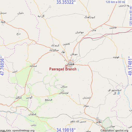
Pasragad Branch GPS coordinates[2]
34° 46' 39.792" North, 48° 28' 18.048" East
| Map corner | latitude | longitude |
|---|---|---|
| Upper-left | 35.35322°, | 47.76856° |
| Center: | 34.77772°, | 48.47168° |
| Lower-right: | 34.19818°, | 49.17481° |
| Map W x H: | 128.4×128.4 km | = 79.8×79.8mi |
| max Lat: | 39.6482° ⇑46% North |
| Pasragad Branch: | 34.77772° |
| min Lat: | ⇓54% South 25.2919° |
| min Long | Pasragad Branch | max Long |
| 44.38416° | 48.47168° | 61.9965° |
| W 23.6%⇐ | ⇒76.4% E |
Elevation
Elevation of Pasragad Branch is 2010 m = 6594 ft, and this is 961 m = 3153 ft above average elevation for this country.
| Max E: |
2564 m = 8412 ft | 6.1% |
| Pasragad Branch | 2010 m 6594 ft | |
| Avg. | 1049 m = 3442 ft | |
Min E: |
-24 m = -79 ft | 93.9% |
See also: Pasragad Branch elevation on elevation.city.
Geographical zone
Pasragad Branch is located in North temperate zone (between Tropic of Cancer and the Arctic Circle). Distance of this Northern Tropic circle is 1261 km =783.5 mi to South.| Distance of | km | miles | from Pasragad Branch |
|---|---|---|---|
| North Pole | 6140.1 | 3815.3 | to North |
| Arctic Circle | 3534.3 | 2196.1 | to North |
| Tropic Cancer | 1261 | 783.5 | to South |
| Equator | 3866.9 | 2402.8 | to South |


Nearby cities:
15 places around Pasragad Branch: (largest is in red/bold)
• Anūch
75 km =46.6 mi,  172°
172°
• Asadābād
32.1 km =19.9 mi,  270°
270°
• Bahār
14.7 km =9.1 mi,  349°
349°
• Fāmenīn
59.2 km =36.8 mi,  50°
50°
• Hamadān
4.6 km =2.9 mi,  58°
58°
• Kabūdarāhang
53.2 km =33.1 mi,  25°
25°
• Kangāvar
55.4 km =34.4 mi,  236°
236°
• Khondāb
78 km =48.5 mi,  123°
123°
• Komījān
78.3 km =48.7 mi,  94°
94°
• Malāyer
61.9 km =38.5 mi,  148°
148°
• Nahāvand
65.9 km =40.9 mi,  187°
187°
• Qorveh
74.5 km =46.3 mi,  305°
305°
• Tūyserkān
25.3 km =15.7 mi, 185°
• Āzādshahr
9.1 km =5.7 mi,  81°
81°
• Şaḩneh
78.7 km =48.9 mi,  245°
245°
Sources, notices
• [Note1] Compared only with cities in Iran existing in our database
• [Src1] Map data: © OpenStreetMap contributors (CC-BY-SA)
• [Src2] Other city data from geonames.org with taken over terms of usage.
• [Src3] Geographical zone / Annual Mean Temperature by Robert A. Rohde @ Wikipedia
