Āzādshahr geodata
Āzādshahr (Hamadān) is a populated place; located in Iran in Asia/Tehran (GMT+3.5) time zone. With population of 514,102 people, there are 16 cities with bigger population in this country. Compared to other cities in Iran, 54.6% of cities are located further ↓South; 75.3% of cities are located further →East and 90% of cities have lower elevation than Āzādshahr. Note1


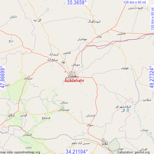
Āzādshahr GPS coordinates[2]
34° 47' 25.764" North, 48° 34' 12.396" East
| Map corner | latitude | longitude |
|---|---|---|
| Upper-left | 35.3659°, | 47.86699° |
| Center: | 34.79049°, | 48.57011° |
| Lower-right: | 34.21104°, | 49.27324° |
| Map W x H: | 128.4×128.4 km | = 79.8×79.8mi |
| max Lat: | 39.6482° ⇑45.4% North |
| Āzādshahr: | 34.79049° |
| min Lat: | ⇓54.6% South 25.2919° |
| min Long | Āzādshahr | max Long |
| 44.38416° | 48.57011° | 61.9965° |
| W 24.7%⇐ | ⇒75.3% E |
Elevation
Elevation of Āzādshahr is 1853 m = 6079 ft, and this is 804 m = 2638 ft above average elevation for this country.
| Max E: |
2564 m = 8412 ft | 10% |
| Āzādshahr | 1853 m 6079 ft | |
| Avg. | 1049 m = 3442 ft | |
Min E: |
-24 m = -79 ft | 90% |
See also: Āzādshahr elevation on elevation.city.
Geographical zone
Āzādshahr is located in North temperate zone (between Tropic of Cancer and the Arctic Circle). Distance of this Northern Tropic circle is 1262.4 km =784.4 mi to South.| Distance of | km | miles | from Āzādshahr |
|---|---|---|---|
| North Pole | 6138.7 | 3814.4 | to North |
| Arctic Circle | 3532.8 | 2195.2 | to North |
| Tropic Cancer | 1262.4 | 784.4 | to South |
| Equator | 3868.3 | 2403.6 | to South |


Nearby cities:
15 places around Āzādshahr: (largest is in red/bold)
• Anūch
75.9 km =47.2 mi,  179°
179°
• Asadābād
41.1 km =25.5 mi,  268°
268°
• Bahār
17.5 km =10.9 mi,  317°
317°
• Fāmenīn
51.6 km =32.1 mi,  45°
45°
• Hamadān
5.2 km =3.2 mi,  280°
280°
• Kabūdarāhang
48.6 km =30.2 mi,  16°
16°
• Kangāvar
63.8 km =39.6 mi,  240°
240°
• Khondāb
71.5 km =44.4 mi,  128°
128°
• Komījān
69.5 km =43.2 mi,  96°
96°
• Malāyer
59 km =36.7 mi,  157°
157°
• Nahāvand
69 km =42.9 mi,  195°
195°
• Pasragad Branch
9.1 km =5.7 mi,  261°
261°
• Qorveh
81.2 km =50.5 mi,  300°
300°
• Razan
78.5 km =48.8 mi,  32°
32°
• Tūyserkān
29 km =18 mi, 203°
Sources, notices
• [Note1] Compared only with cities in Iran existing in our database
• [Src1] Map data: © OpenStreetMap contributors (CC-BY-SA)
• [Src2] Other city data from geonames.org with taken over terms of usage.
• [Src3] Geographical zone / Annual Mean Temperature by Robert A. Rohde @ Wikipedia
