Kitale geodata
Kitale (Trans Nzoia) is a seat of a first-order administrative division; located in Kenya in Africa/Nairobi (GMT+3) time zone. With population of 75,123 people, there are 7 cities with bigger population in this country. Compared to other cities in Kenya, 93% of cities are located further ↓South; 75.4% of cities are located further →East and 77.2% of cities have lower elevation than Kitale. Note1


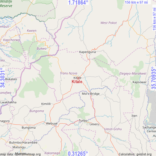
Kitale GPS coordinates[2]
1° 0' 56.592" North, 35° 0' 22.392" East
| Map corner | latitude | longitude |
|---|---|---|
| Upper-left | 1.71864°, | 34.3031° |
| Center: | 1.01572°, | 35.00622° |
| Lower-right: | 0.31265°, | 35.70935° |
| Map W x H: | 156.3×156.3 km | = 97.1×97.1mi |
| max Lat: | 3.93726° ⇑7% North |
| Kitale: | 1.01572° |
| min Lat: | ⇓93% South -4.64756° |
| min Long | Kitale | max Long |
| 33.97248° | 35.00622° | 41.85688° |
| W 24.6%⇐ | ⇒75.4% E |
Elevation
Elevation of Kitale is 1900 m = 6234 ft, and this is 553.3 m = 1815 ft above average elevation for this country.
| Max E: |
2514 m = 8248 ft | 22.8% |
| Kitale | 1900 m 6234 ft | |
| Avg. | 1346.7 m = 4418 ft | |
Min E: |
7 m = 23 ft | 77.2% |
See also: Kitale elevation on elevation.city.
Geographical zone
Kitale is located in North Torrid zone (between Equator and Tropic of Cancer). Distance of Equator is 112.9 km =70.2 mi to South.| Distance of | km | miles | from Kitale |
|---|---|---|---|
| North Pole | 9894.1 | 6147.9 | to North |
| Arctic Circle | 7288.2 | 4528.7 | to North |
| Tropic Cancer | 2493 | 1549.1 | to North |
| Equator | 112.9 | 70.2 | to South |


Nearby cities:
15 places around Kitale: (largest is in red/bold)
• Bungoma
67.2 km =41.8 mi,  224°
224°
• Bungoma
70.6 km =43.9 mi, 224°
• Chepareria
39 km =24.2 mi,  34°
34°
• Eldoret
62.4 km =38.8 mi,  151°
151°
• Iten
67.7 km =42.1 mi,  124°
124°
• Kabarnet
100.5 km =62.4 mi,  125°
125°
• Kakamega
86.1 km =53.5 mi,  199°
199°
• Kapenguria
27.5 km =17.1 mi, 25°
• Kapsabet
90.9 km =56.5 mi,  173°
173°
• Kapsowar
61.5 km =38.2 mi,  93°
93°
• Malaba
91 km =56.5 mi,  242°
242°
• Malikisi
75.1 km =46.7 mi, 239°
• Mumias
95.1 km =59.1 mi, 217°
• Nandi Hills
103.3 km =64.2 mi, 168°
• Webuye
53.1 km =33 mi,  209°
209°
Sources, notices
• [Note1] Compared only with cities in Kenya existing in our database
• [Src1] Map data: © OpenStreetMap contributors (CC-BY-SA)
• [Src2] Other city data from geonames.org with taken over terms of usage.
• [Src3] Geographical zone / Annual Mean Temperature by Robert A. Rohde @ Wikipedia
