Maralal geodata
Maralal (Samburu) is a seat of a first-order administrative division; located in Kenya in Africa/Nairobi (GMT+3) time zone. With population of 20,841 people, there are 44 cities with bigger population in this country. Compared to other cities in Kenya, 93.9% of cities are located further ↓South; 52.6% of cities are located further ←West and 79.8% of cities have lower elevation than Maralal. Note1


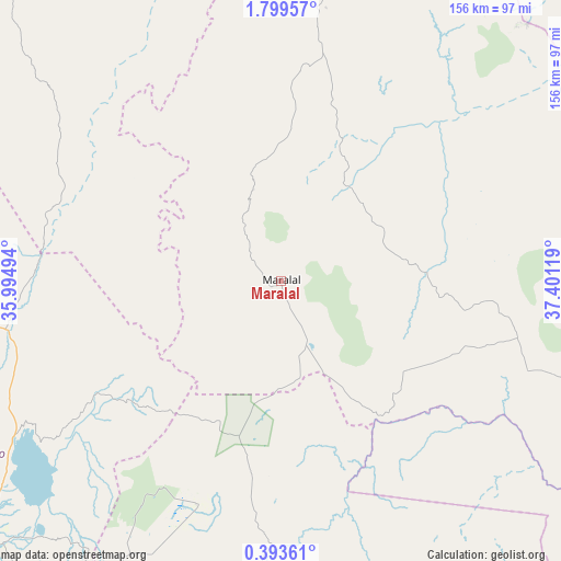
Maralal GPS coordinates[2]
1° 5' 48.012" North, 36° 41' 53.016" East
| Map corner | latitude | longitude |
|---|---|---|
| Upper-left | 1.79957°, | 35.99494° |
| Center: | 1.09667°, | 36.69806° |
| Lower-right: | 0.39361°, | 37.40119° |
| Map W x H: | 156.3×156.3 km | = 97.1×97.1mi |
| max Lat: | 3.93726° ⇑6.1% North |
| Maralal: | 1.09667° |
| min Lat: | ⇓93.9% South -4.64756° |
| min Long | Maralal | max Long |
| 33.97248° | 36.69806° | 41.85688° |
| W 52.6%⇐ | ⇒47.4% E |
Elevation
Elevation of Maralal is 1941 m = 6368 ft, and this is 594.3 m = 1950 ft above average elevation for this country.
| Max E: |
2514 m = 8248 ft | 20.2% |
| Maralal | 1941 m 6368 ft | |
| Avg. | 1346.7 m = 4418 ft | |
Min E: |
7 m = 23 ft | 79.8% |
See also: Kenya elevation on elevation.city.
Geographical zone
Maralal is located in North Torrid zone (between Equator and Tropic of Cancer). Distance of Equator is 121.9 km =75.7 mi to South.| Distance of | km | miles | from Maralal |
|---|---|---|---|
| North Pole | 9885.1 | 6142.3 | to North |
| Arctic Circle | 7279.2 | 4523.1 | to North |
| Tropic Cancer | 2484 | 1543.5 | to North |
| Equator | 121.9 | 75.7 | to South |


Nearby cities:
15 places around Maralal: (largest is in red/bold)
• Baringo
107.3 km =66.7 mi,  229°
229°
• Chepareria
167.7 km =104.2 mi,  277°
277°
• Eldama Ravine
158.6 km =98.5 mi,  222°
222°
• Isiolo
128.3 km =79.7 mi,  130°
130°
• Iten
140.5 km =87.3 mi,  250°
250°
• Kabarnet
125.7 km =78.1 mi,  237°
237°
• Kapsowar
127.4 km =79.2 mi,  264°
264°
• Maua
168.3 km =104.6 mi,  124°
124°
• Meru
158.1 km =98.2 mi,  137°
137°
• Nanyuki
128.2 km =79.7 mi,  160°
160°
• Naro Moru
144.6 km =89.9 mi,  165°
165°
• Nyahururu
123.4 km =76.7 mi,  197°
197°
• Ol Kalou
156.1 km =97 mi,  193°
193°
• Rongai
169 km =105 mi,  213°
213°
• Rumuruti
93.3 km =58 mi, 190°
Sources, notices
• [Note1] Compared only with cities in Kenya existing in our database
• [Src1] Map data: © OpenStreetMap contributors (CC-BY-SA)
• [Src2] Other city data from geonames.org with taken over terms of usage.
• [Src3] Geographical zone / Annual Mean Temperature by Robert A. Rohde @ Wikipedia
