Chepareria geodata
Chepareria (West Pokot) is a populated place; located in Kenya in Africa/Nairobi (GMT+3) time zone. With population of 1,073 people, there are 108 cities with bigger population in this country. Compared to other cities in Kenya, 95.6% of cities are located further ↓South; 69.3% of cities are located further →East and 68.4% of cities have lower elevation than Chepareria. Note1


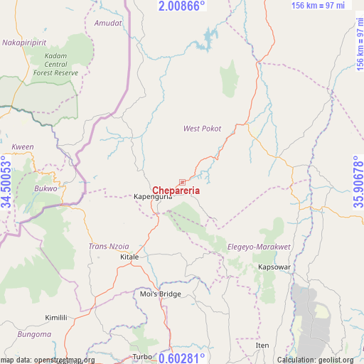
Chepareria GPS coordinates[2]
1° 18' 20.988" North, 35° 12' 13.14" East
| Map corner | latitude | longitude |
|---|---|---|
| Upper-left | 2.00866°, | 34.50053° |
| Center: | 1.30583°, | 35.20365° |
| Lower-right: | 0.60281°, | 35.90678° |
| Map W x H: | 156.3×156.3 km | = 97.1×97.1mi |
| max Lat: | 3.93726° ⇑4.4% North |
| Chepareria: | 1.30583° |
| min Lat: | ⇓95.6% South -4.64756° |
| min Long | Chepareria | max Long |
| 33.97248° | 35.20365° | 41.85688° |
| W 30.7%⇐ | ⇒69.3% E |
Elevation
Elevation of Chepareria is 1723 m = 5653 ft, and this is 376.3 m = 1235 ft above average elevation for this country.
| Max E: |
2514 m = 8248 ft | 31.6% |
| Chepareria | 1723 m 5653 ft | |
| Avg. | 1346.7 m = 4418 ft | |
Min E: |
7 m = 23 ft | 68.4% |
See also: Kenya elevation on elevation.city.
Geographical zone
Chepareria is located in North Torrid zone (between Equator and Tropic of Cancer). Distance of Equator is 145.2 km =90.2 mi to South.| Distance of | km | miles | from Chepareria |
|---|---|---|---|
| North Pole | 9861.9 | 6127.9 | to North |
| Arctic Circle | 7256 | 4508.7 | to North |
| Tropic Cancer | 2460.7 | 1529 | to North |
| Equator | 145.2 | 90.2 | to South |


Nearby cities:
15 places around Chepareria: (largest is in red/bold)
• Baringo
126.1 km =78.4 mi,  137°
137°
• Bungoma
105.9 km =65.8 mi,  220°
220°
• Bungoma
109.2 km =67.9 mi, 220°
• Eldoret
87.6 km =54.4 mi,  175°
175°
• Iten
78.4 km =48.7 mi,  154°
154°
• Kabarnet
108.6 km =67.5 mi, 146°
• Kakamega
124.2 km =77.2 mi,  203°
203°
• Kapenguria
12.6 km =7.8 mi,  233°
233°
• Kapsabet
123 km =76.4 mi,  185°
185°
• Kapsowar
53.6 km =33.3 mi,  132°
132°
• Kitale
39 km =24.2 mi,  214°
214°
• Malaba
126.8 km =78.8 mi, 233°
• Malikisi
111.6 km =69.3 mi, 231°
• Nandi Hills
133.7 km =83.1 mi, 180°
• Webuye
92 km =57.2 mi, 211°
Sources, notices
• [Note1] Compared only with cities in Kenya existing in our database
• [Src1] Map data: © OpenStreetMap contributors (CC-BY-SA)
• [Src2] Other city data from geonames.org with taken over terms of usage.
• [Src3] Geographical zone / Annual Mean Temperature by Robert A. Rohde @ Wikipedia
