Kapenguria geodata
Kapenguria (West Pokot) is a seat of a first-order administrative division; located in Kenya in Africa/Nairobi (GMT+3) time zone. With population of 56,000 people, there are 10 cities with bigger population in this country. Compared to other cities in Kenya, 94.7% of cities are located further ↓South; 72.8% of cities are located further →East and 86% of cities have lower elevation than Kapenguria. Note1


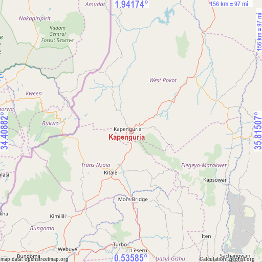
Kapenguria GPS coordinates[2]
1° 14' 20.004" North, 35° 6' 42.984" East
| Map corner | latitude | longitude |
|---|---|---|
| Upper-left | 1.94174°, | 34.40882° |
| Center: | 1.23889°, | 35.11194° |
| Lower-right: | 0.53585°, | 35.81507° |
| Map W x H: | 156.3×156.3 km | = 97.1×97.1mi |
| max Lat: | 3.93726° ⇑5.3% North |
| Kapenguria: | 1.23889° |
| min Lat: | ⇓94.7% South -4.64756° |
| min Long | Kapenguria | max Long |
| 33.97248° | 35.11194° | 41.85688° |
| W 27.2%⇐ | ⇒72.8% E |
Elevation
Elevation of Kapenguria is 2020 m = 6627 ft, and this is 673.3 m = 2209 ft above average elevation for this country.
| Max E: |
2514 m = 8248 ft | 14% |
| Kapenguria | 2020 m 6627 ft | |
| Avg. | 1346.7 m = 4418 ft | |
Min E: |
7 m = 23 ft | 86% |
See also: Kapenguria elevation on elevation.city.
Geographical zone
Kapenguria is located in North Torrid zone (between Equator and Tropic of Cancer). Distance of Equator is 137.8 km =85.6 mi to South.| Distance of | km | miles | from Kapenguria |
|---|---|---|---|
| North Pole | 9869.3 | 6132.5 | to North |
| Arctic Circle | 7263.4 | 4513.3 | to North |
| Tropic Cancer | 2468.2 | 1533.7 | to North |
| Equator | 137.8 | 85.6 | to South |


Nearby cities:
15 places around Kapenguria: (largest is in red/bold)
• Bungoma
93.6 km =58.2 mi,  218°
218°
• Bungoma
96.9 km =60.2 mi, 219°
• Chepareria
12.6 km =7.8 mi,  53°
53°
• Eldoret
81.8 km =50.8 mi,  167°
167°
• Iten
77 km =47.8 mi,  145°
145°
• Kabarnet
108.7 km =67.5 mi,  139°
139°
• Kakamega
113.4 km =70.5 mi,  200°
200°
• Kapsabet
115.1 km =71.5 mi,  180°
180°
• Kapsowar
57.5 km =35.7 mi,  120°
120°
• Kitale
27.5 km =17.1 mi,  205°
205°
• Malaba
114.1 km =70.9 mi,  233°
233°
• Malikisi
99 km =61.5 mi, 230°
• Mumias
122.1 km =75.9 mi, 214°
• Nandi Hills
126.5 km =78.6 mi, 176°
• Webuye
80.5 km =50 mi, 208°
Sources, notices
• [Note1] Compared only with cities in Kenya existing in our database
• [Src1] Map data: © OpenStreetMap contributors (CC-BY-SA)
• [Src2] Other city data from geonames.org with taken over terms of usage.
• [Src3] Geographical zone / Annual Mean Temperature by Robert A. Rohde @ Wikipedia
