Pokrovka geodata
Pokrovka (Talas) is a seat of a second-order administrative division; located in Kyrgyzstan in Asia/Bishkek (GMT+6) time zone. In our database, there are 37 cities with bigger population. Compared to other cities in Kyrgyzstan, 86.9% of cities are located further ↓South; 71.4% of cities are located further →East and 78.6% of cities have higher elevation than Pokrovka. Note1


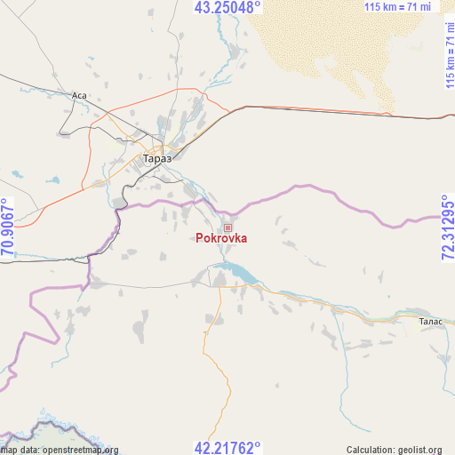
Pokrovka GPS coordinates[2]
42° 44' 10.32" North, 71° 36' 35.352" East
| Map corner | latitude | longitude |
|---|---|---|
| Upper-left | 43.25048°, | 70.9067° |
| Center: | 42.7362°, | 71.60982° |
| Lower-right: | 42.21762°, | 72.31295° |
| Map W x H: | 114.8×114.8 km | = 71.3×71.3mi |
| max Lat: | 42.89106° ⇑13.1% North |
| Pokrovka: | 42.7362° |
| min Lat: | ⇓86.9% South 39.55274° |
| min Long | Pokrovka | max Long |
| 69.3716° | 71.60982° | 78.52702° |
| W 28.6%⇐ | ⇒71.4% E |
Elevation
Elevation of Pokrovka is 768 m = 2520 ft, and this is 433.4 m = 1422 ft below average elevation for this country.
| Max E: |
2638 m = 8655 ft | 78.6% |
| Avg. | 1201.4 m = 3942 ft | |
| Pokrovka | 768 m = 2520 ft | |
Min E: |
504 m = 1654 ft | 21.4% |
See also: Kyrgyzstan elevation on elevation.city.
Geographical zone
Pokrovka is located in North temperate zone (between Tropic of Cancer and the Arctic Circle). Distance of this Northern Tropic circle is 2145.9 km =1333.4 mi to South.| Distance of | km | miles | from Pokrovka |
|---|---|---|---|
| North Pole | 5255.2 | 3265.4 | to North |
| Arctic Circle | 2649.4 | 1646.3 | to North |
| Tropic Cancer | 2145.9 | 1333.4 | to South |
| Equator | 4751.8 | 2952.6 | to South |


Nearby cities:
15 places around Pokrovka: (largest is in red/bold)
• Ala-Buka
147.8 km =91.8 mi,  183°
183°
• Bakai-Ata
37.3 km =23.2 mi,  136°
136°
• Ivanovo-Alekseyevka
53.4 km =33.2 mi,  113°
113°
• Kaindy
168.9 km =104.9 mi,  86°
86°
• Kanysh-Kyya
116.1 km =72.1 mi,  201°
201°
• Kara-Balta
182.9 km =113.6 mi, 87°
• Kerben
138.7 km =86.2 mi,  174°
174°
• Kochkor-Ata
202.3 km =125.7 mi,  159°
159°
• Kyzyl-Adyr
13.1 km =8.1 mi,  187°
187°
• Sosnovka
187.2 km =116.3 mi, 93°
• Talas
57 km =35.4 mi, 114°
• Talas
95.7 km =59.5 mi,  116°
116°
• Tash-Kumyr
162.5 km =101 mi, 162°
• Toktogul
145.5 km =90.4 mi,  131°
131°
• Üch-Terek
169.9 km =105.6 mi, 129°
Sources, notices
• [Note1] Compared only with cities in Kyrgyzstan existing in our database
• [Src1] Map data: © OpenStreetMap contributors (CC-BY-SA)
• [Src2] Other city data from geonames.org with taken over terms of usage.
• [Src3] Geographical zone / Annual Mean Temperature by Robert A. Rohde @ Wikipedia
