Aktobe geodata
Aktobe (Aqtöbe) is a seat of a first-order administrative division; located in Kazakhstan in Asia/Aqtobe (GMT+5) time zone. With population of 262,457 people, there are 9 cities with bigger population in this country. Compared to other cities in Kazakhstan, 69.6% of cities are located further ↓South; 83% of cities are located further →East and 63.7% of cities have higher elevation than Aktobe. Note1


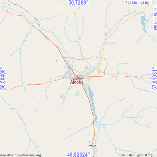
Aktobe GPS coordinates[2]
50° 16' 46.884" North, 57° 12' 25.848" East
| Map corner | latitude | longitude |
|---|---|---|
| Upper-left | 50.7269°, | 56.50406° |
| Center: | 50.27969°, | 57.20718° |
| Lower-right: | 49.82824°, | 57.91031° |
| Map W x H: | 99.9×99.9 km | = 62.1×62.1mi |
| max Lat: | 54.90596° ⇑30.4% North |
| Aktobe: | 50.27969° |
| min Lat: | ⇓69.6% South 40.66338° |
| min Long | Aktobe | max Long |
| 46.83361° | 57.20718° | 84.87144° |
| W 17%⇐ | ⇒83% E |
Elevation
Elevation of Aktobe is 210 m = 689 ft, and this is 146.5 m = 481 ft below average elevation for this country.
| Max E: |
1847 m = 6060 ft | 63.7% |
| Avg. | 356.5 m = 1170 ft | |
| Aktobe | 210 m = 689 ft | |
Min E: |
-26 m = -85 ft | 36.3% |
See also: Aktobe elevation on elevation.city.
Geographical zone
Aktobe is located in North temperate zone (between Tropic of Cancer and the Arctic Circle). Distance of this North polar circle is 1810.6 km =1125.1 mi to North.| Distance of | km | miles | from Aktobe |
|---|---|---|---|
| North Pole | 4416.5 | 2744.3 | to North |
| Arctic Circle | 1810.6 | 1125.1 | to North |
| Tropic Cancer | 2984.7 | 1854.6 | to South |
| Equator | 5590.6 | 3473.8 | to South |


Nearby cities:
12 places around Aktobe: (largest is in red/bold)
• Batamshinskiy
82 km =51 mi,  67°
67°
• Bayganin
201.3 km =125.1 mi,  208°
208°
• Chingirlau
238.1 km =147.9 mi,  292°
292°
• Embi
175 km =108.7 mi,  157°
157°
• Kandyagash
91.4 km =56.8 mi,  170°
170°
• Khromtau
87.7 km =54.5 mi,  92°
92°
• Martuk
71.8 km =44.6 mi,  316°
316°
• Miyaly
290.9 km =180.8 mi,  237°
237°
• Shalqar
323.1 km =200.8 mi,  147°
147°
• Shubarkuduk
136.6 km =84.9 mi,  202°
202°
• Shubarshi
189 km =117.4 mi,  180°
180°
• Temir
126.7 km =78.7 mi, 182°
Sources, notices
• [Note1] Compared only with cities in Kazakhstan existing in our database
• [Src1] Map data: © OpenStreetMap contributors (CC-BY-SA)
• [Src2] Other city data from geonames.org with taken over terms of usage.
• [Src3] Geographical zone / Annual Mean Temperature by Robert A. Rohde @ Wikipedia
