Bayganin geodata
Bayganin (Aqtöbe) is a populated place; located in Kazakhstan in Asia/Aqtobe (GMT+5) time zone. With population of 7,657 people, there are 149 cities with bigger population in this country. Compared to other cities in Kazakhstan, 51.5% of cities are located further ↑North; 84.8% of cities are located further →East and 66.3% of cities have higher elevation than Bayganin. Note1


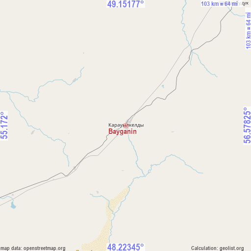
Bayganin GPS coordinates[2]
48° 41' 23.1" North, 55° 52' 30.432" East
| Map corner | latitude | longitude |
|---|---|---|
| Upper-left | 49.15177°, | 55.172° |
| Center: | 48.68975°, | 55.87512° |
| Lower-right: | 48.22345°, | 56.57825° |
| Map W x H: | 103.2×103.2 km | = 64.1×64.1mi |
| max Lat: | 54.90596° ⇑51.5% North |
| Bayganin: | 48.68975° |
| min Lat: | ⇓48.5% South 40.66338° |
| min Long | Bayganin | max Long |
| 46.83361° | 55.87512° | 84.87144° |
| W 15.2%⇐ | ⇒84.8% E |
Elevation
Elevation of Bayganin is 198 m = 650 ft, and this is 158.5 m = 520 ft below average elevation for this country.
| Max E: |
1847 m = 6060 ft | 66.3% |
| Avg. | 356.5 m = 1170 ft | |
| Bayganin | 198 m = 650 ft | |
Min E: |
-26 m = -85 ft | 33.7% |
See also: Kazakhstan elevation on elevation.city.
Geographical zone
Bayganin is located in North temperate zone (between Tropic of Cancer and the Arctic Circle). Distance of this North polar circle is 1987.4 km =1234.9 mi to North.| Distance of | km | miles | from Bayganin |
|---|---|---|---|
| North Pole | 4593.3 | 2854.1 | to North |
| Arctic Circle | 1987.4 | 1234.9 | to North |
| Tropic Cancer | 2807.9 | 1744.7 | to South |
| Equator | 5413.8 | 3364 | to South |


Nearby cities:
15 places around Bayganin: (largest is in red/bold)
• Akkol’
197.4 km =122.7 mi,  272°
272°
• Aktobe
201.3 km =125.1 mi,  28°
28°
• Batamshinskiy
270.5 km =168.1 mi,  39°
39°
• Biikzhal
227.8 km =141.5 mi,  202°
202°
• Dossor
250.7 km =155.8 mi,  238°
238°
• Embi
167.5 km =104.1 mi,  84°
84°
• Kandyagash
142 km =88.2 mi,  52°
52°
• Khromtau
253.9 km =157.8 mi, 46°
• Maqat
222.2 km =138.1 mi, 238°
• Martuk
233.2 km =144.9 mi,  11°
11°
• Miyaly
154.1 km =95.8 mi,  278°
278°
• Qulsary
237.6 km =147.6 mi,  215°
215°
• Shubarkuduk
67.2 km =41.8 mi, 41°
• Shubarshi
96.9 km =60.2 mi,  97°
97°
• Temir
104.4 km =64.9 mi,  61°
61°
Sources, notices
• [Note1] Compared only with cities in Kazakhstan existing in our database
• [Src1] Map data: © OpenStreetMap contributors (CC-BY-SA)
• [Src2] Other city data from geonames.org with taken over terms of usage.
• [Src3] Geographical zone / Annual Mean Temperature by Robert A. Rohde @ Wikipedia
