Khromtau geodata
Khromtau (Aqtöbe) is a populated place; located in Kazakhstan in Asia/Aqtobe (GMT+5) time zone. With population of 23,715 people, there are 60 cities with bigger population in this country. Compared to other cities in Kazakhstan, 68.5% of cities are located further ↓South; 81.5% of cities are located further →East and 65.9% of cities have lower elevation than Khromtau. Note1


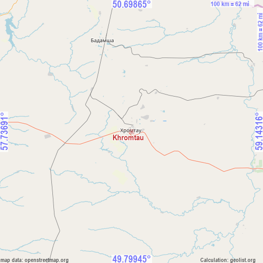
Khromtau GPS coordinates[2]
50° 15' 4.212" North, 58° 26' 24.108" East
| Map corner | latitude | longitude |
|---|---|---|
| Upper-left | 50.69865°, | 57.73691° |
| Center: | 50.25117°, | 58.44003° |
| Lower-right: | 49.79945°, | 59.14316° |
| Map W x H: | 100×100 km | = 62.1×62.1mi |
| max Lat: | 54.90596° ⇑31.5% North |
| Khromtau: | 50.25117° |
| min Lat: | ⇓68.5% South 40.66338° |
| min Long | Khromtau | max Long |
| 46.83361° | 58.44003° | 84.87144° |
| W 18.5%⇐ | ⇒81.5% E |
Elevation
Elevation of Khromtau is 429 m = 1407 ft, and this is 72.5 m = 238 ft above average elevation for this country.
| Max E: |
1847 m = 6060 ft | 34.1% |
| Khromtau | 429 m 1407 ft | |
| Avg. | 356.5 m = 1170 ft | |
Min E: |
-26 m = -85 ft | 65.9% |
See also: Kazakhstan elevation on elevation.city.
Geographical zone
Khromtau is located in North temperate zone (between Tropic of Cancer and the Arctic Circle). Distance of this North polar circle is 1813.8 km =1127 mi to North.| Distance of | km | miles | from Khromtau |
|---|---|---|---|
| North Pole | 4419.7 | 2746.3 | to North |
| Arctic Circle | 1813.8 | 1127 | to North |
| Tropic Cancer | 2981.5 | 1852.6 | to South |
| Equator | 5587.4 | 3471.8 | to South |


Nearby cities:
13 places around Khromtau: (largest is in red/bold)
• Aktobe
87.7 km =54.5 mi,  272°
272°
• Batamshinskiy
36.2 km =22.5 mi,  341°
341°
• Bayganin
253.9 km =157.8 mi,  226°
226°
• Dzhetygara
288.7 km =179.4 mi,  41°
41°
• Embi
159.4 km =99 mi,  187°
187°
• Kandyagash
113.6 km =70.6 mi,  220°
220°
• Martuk
147.5 km =91.7 mi,  291°
291°
• Ordzhonikidze
335.3 km =208.3 mi, 43°
• Shalqar
281.8 km =175.1 mi,  162°
162°
• Shubarkuduk
187 km =116.2 mi, 228°
• Shubarshi
206.8 km =128.5 mi,  206°
206°
• Temir
155.3 km =96.5 mi, 217°
• Yrghyz
273.5 km =169.9 mi,  131°
131°
Sources, notices
• [Note1] Compared only with cities in Kazakhstan existing in our database
• [Src1] Map data: © OpenStreetMap contributors (CC-BY-SA)
• [Src2] Other city data from geonames.org with taken over terms of usage.
• [Src3] Geographical zone / Annual Mean Temperature by Robert A. Rohde @ Wikipedia
