Martuk geodata
Martuk (Aqtöbe) is a populated place; located in Kazakhstan in Asia/Aqtobe (GMT+5) time zone. With population of 7,756 people, there are 146 cities with bigger population in this country. Compared to other cities in Kazakhstan, 72.6% of cities are located further ↓South; 84.1% of cities are located further →East and 70% of cities have higher elevation than Martuk. Note1


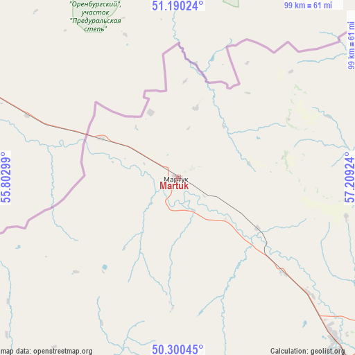
Martuk GPS coordinates[2]
50° 44' 50.856" North, 56° 30' 21.996" East
| Map corner | latitude | longitude |
|---|---|---|
| Upper-left | 51.19024°, | 55.80299° |
| Center: | 50.74746°, | 56.50611° |
| Lower-right: | 50.30045°, | 57.20924° |
| Map W x H: | 98.9×98.9 km | = 61.5×61.5mi |
| max Lat: | 54.90596° ⇑27.4% North |
| Martuk: | 50.74746° |
| min Lat: | ⇓72.6% South 40.66338° |
| min Long | Martuk | max Long |
| 46.83361° | 56.50611° | 84.87144° |
| W 15.9%⇐ | ⇒84.1% E |
Elevation
Elevation of Martuk is 176 m = 577 ft, and this is 180.5 m = 592 ft below average elevation for this country.
| Max E: |
1847 m = 6060 ft | 70% |
| Avg. | 356.5 m = 1170 ft | |
| Martuk | 176 m = 577 ft | |
Min E: |
-26 m = -85 ft | 30% |
See also: Kazakhstan elevation on elevation.city.
Geographical zone
Martuk is located in North temperate zone (between Tropic of Cancer and the Arctic Circle). Distance of this North polar circle is 1758.6 km =1092.7 mi to North.| Distance of | km | miles | from Martuk |
|---|---|---|---|
| North Pole | 4364.5 | 2712 | to North |
| Arctic Circle | 1758.6 | 1092.7 | to North |
| Tropic Cancer | 3036.7 | 1886.9 | to South |
| Equator | 5642.6 | 3506.1 | to South |


Nearby cities:
15 places around Martuk: (largest is in red/bold)
• Akkol’
324.2 km =201.4 mi,  227°
227°
• Aktobe
71.8 km =44.6 mi,  136°
136°
• Aqsay
250.1 km =155.4 mi,  280°
280°
• Batamshinskiy
126.6 km =78.7 mi,  99°
99°
• Bayganin
233.2 km =144.9 mi,  191°
191°
• Burlin
275.4 km =171.1 mi,  285°
285°
• Chingirlau
174.2 km =108.2 mi, 282°
• Dzhambeyty
281.6 km =175 mi,  258°
258°
• Embi
243.7 km =151.4 mi,  151°
151°
• Kandyagash
156.3 km =97.1 mi,  155°
155°
• Khromtau
147.5 km =91.7 mi,  111°
111°
• Miyaly
284.2 km =176.6 mi,  223°
223°
• Shubarkuduk
178.3 km =110.8 mi,  180°
180°
• Shubarshi
245.8 km =152.7 mi,  168°
168°
• Temir
184.1 km =114.4 mi, 165°
Sources, notices
• [Note1] Compared only with cities in Kazakhstan existing in our database
• [Src1] Map data: © OpenStreetMap contributors (CC-BY-SA)
• [Src2] Other city data from geonames.org with taken over terms of usage.
• [Src3] Geographical zone / Annual Mean Temperature by Robert A. Rohde @ Wikipedia
