Pavlodar geodata
Pavlodar (Pavlodar Region) is a seat of a first-order administrative division; located in Kazakhstan in Asia/Almaty (GMT+5) time zone. With population of 329,002 people, there are 5 cities with bigger population in this country. Compared to other cities in Kazakhstan, 84.4% of cities are located further ↓South; 80% of cities are located further ←West and 76.7% of cities have higher elevation than Pavlodar. Note1


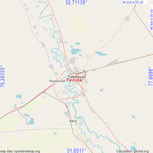
Pavlodar GPS coordinates[2]
52° 16' 59.988" North, 76° 58' 0.012" East
| Map corner | latitude | longitude |
|---|---|---|
| Upper-left | 52.71139°, | 76.26355° |
| Center: | 52.28333°, | 76.96667° |
| Lower-right: | 51.8511°, | 77.6698° |
| Map W x H: | 95.7×95.7 km | = 59.5×59.5mi |
| max Lat: | 54.90596° ⇑15.6% North |
| Pavlodar: | 52.28333° |
| min Lat: | ⇓84.4% South 40.66338° |
| min Long | Pavlodar | max Long |
| 46.83361° | 76.96667° | 84.87144° |
| W 80%⇐ | ⇒20% E |
Elevation
Elevation of Pavlodar is 133 m = 436 ft, and this is 223.5 m = 733 ft below average elevation for this country.
| Max E: |
1847 m = 6060 ft | 76.7% |
| Avg. | 356.5 m = 1170 ft | |
| Pavlodar | 133 m = 436 ft | |
Min E: |
-26 m = -85 ft | 23.3% |
See also: Pavlodar elevation on elevation.city.
Geographical zone
Pavlodar is located in North temperate zone (between Tropic of Cancer and the Arctic Circle). Distance of this North polar circle is 1587.8 km =986.6 mi to North.| Distance of | km | miles | from Pavlodar |
|---|---|---|---|
| North Pole | 4193.7 | 2605.8 | to North |
| Arctic Circle | 1587.8 | 986.6 | to North |
| Tropic Cancer | 3207.4 | 1993 | to South |
| Equator | 5813.4 | 3612.3 | to South |


Nearby cities:
15 places around Pavlodar: (largest is in red/bold)
• Aksu
27.2 km =16.9 mi,  185°
185°
• Bayanaul
187.4 km =116.4 mi,  207°
207°
• Belogor’ye
90.7 km =56.4 mi,  157°
157°
• Bestobe
263.7 km =163.9 mi,  275°
275°
• Ekibastuz
128.6 km =79.9 mi,  241°
241°
• Irtyshsk
154.7 km =96.1 mi,  319°
319°
• Kalkaman
73.9 km =45.9 mi, 240°
• Kurchatov
201.8 km =125.4 mi,  147°
147°
• Leninskiy
13 km =8.1 mi,  255°
255°
• Mayqayyng
121.5 km =75.5 mi,  221°
221°
• Prigorodnoye
303.9 km =188.8 mi,  198°
198°
• Qashyr
104.7 km =65.1 mi,  326°
326°
• Semey
308.4 km =191.6 mi,  132°
132°
• Yermentau
274.7 km =170.7 mi,  254°
254°
• Zhelezinka
178.3 km =110.8 mi, 321°
Sources, notices
• [Note1] Compared only with cities in Kazakhstan existing in our database
• [Src1] Map data: © OpenStreetMap contributors (CC-BY-SA)
• [Src2] Other city data from geonames.org with taken over terms of usage.
• [Src3] Geographical zone / Annual Mean Temperature by Robert A. Rohde @ Wikipedia
