Aksu geodata
Aksu (Pavlodar Region) is a populated place; located in Kazakhstan in Asia/Almaty (GMT+5) time zone. With population of 44,808 people, there are 32 cities with bigger population in this country. Compared to other cities in Kazakhstan, 83% of cities are located further ↓South; 78.9% of cities are located further ←West and 79.6% of cities have higher elevation than Aksu. Note1


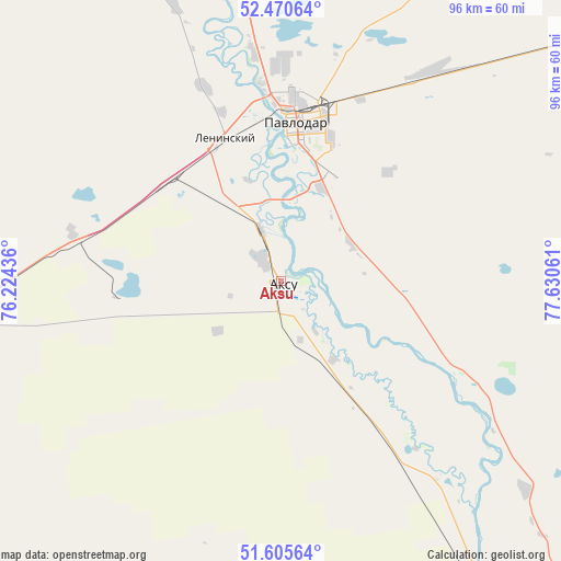
Aksu GPS coordinates[2]
52° 2' 24.828" North, 76° 55' 38.928" East
| Map corner | latitude | longitude |
|---|---|---|
| Upper-left | 52.47064°, | 76.22436° |
| Center: | 52.04023°, | 76.92748° |
| Lower-right: | 51.60564°, | 77.63061° |
| Map W x H: | 96.2×96.2 km | = 59.8×59.8mi |
| max Lat: | 54.90596° ⇑17% North |
| Aksu: | 52.04023° |
| min Lat: | ⇓83% South 40.66338° |
| min Long | Aksu | max Long |
| 46.83361° | 76.92748° | 84.87144° |
| W 78.9%⇐ | ⇒21.1% E |
Elevation
Elevation of Aksu is 123 m = 404 ft, and this is 233.5 m = 766 ft below average elevation for this country.
| Max E: |
1847 m = 6060 ft | 79.6% |
| Avg. | 356.5 m = 1170 ft | |
| Aksu | 123 m = 404 ft | |
Min E: |
-26 m = -85 ft | 20.4% |
See also: Aksu elevation on elevation.city.
Geographical zone
Aksu is located in North temperate zone (between Tropic of Cancer and the Arctic Circle). Distance of this North polar circle is 1614.8 km =1003.4 mi to North.| Distance of | km | miles | from Aksu |
|---|---|---|---|
| North Pole | 4220.7 | 2622.6 | to North |
| Arctic Circle | 1614.8 | 1003.4 | to North |
| Tropic Cancer | 3180.4 | 1976.2 | to South |
| Equator | 5786.3 | 3595.4 | to South |


Nearby cities:
15 places around Aksu: (largest is in red/bold)
• Bayanaul
162.7 km =101.1 mi,  211°
211°
• Belogor’ye
68 km =42.3 mi,  146°
146°
• Bestobe
265.6 km =165 mi,  281°
281°
• Ekibastuz
115.6 km =71.8 mi,  252°
252°
• Irtyshsk
174.6 km =108.5 mi,  325°
325°
• Kalkaman
62.4 km =38.8 mi,  261°
261°
• Kurchatov
181.4 km =112.7 mi,  141°
141°
• Leninskiy
25.7 km =16 mi,  337°
337°
• Mayqayyng
100.8 km =62.6 mi,  230°
230°
• Pavlodar
27.2 km =16.9 mi,  5°
5°
• Prigorodnoye
277.5 km =172.4 mi,  199°
199°
• Qashyr
126.9 km =78.9 mi, 334°
• Semey
293.6 km =182.4 mi,  127°
127°
• Yermentau
266.8 km =165.8 mi, 260°
• Zhelezinka
198.8 km =123.5 mi, 326°
Sources, notices
• [Note1] Compared only with cities in Kazakhstan existing in our database
• [Src1] Map data: © OpenStreetMap contributors (CC-BY-SA)
• [Src2] Other city data from geonames.org with taken over terms of usage.
• [Src3] Geographical zone / Annual Mean Temperature by Robert A. Rohde @ Wikipedia
