Leninskiy geodata
Leninskiy (Pavlodar Region) is a populated place; located in Kazakhstan in Asia/Almaty (GMT+5) time zone. With population of 8,646 people, there are 138 cities with bigger population in this country. Compared to other cities in Kazakhstan, 84.1% of cities are located further ↓South; 78.1% of cities are located further ←West and 81.9% of cities have higher elevation than Leninskiy. Note1


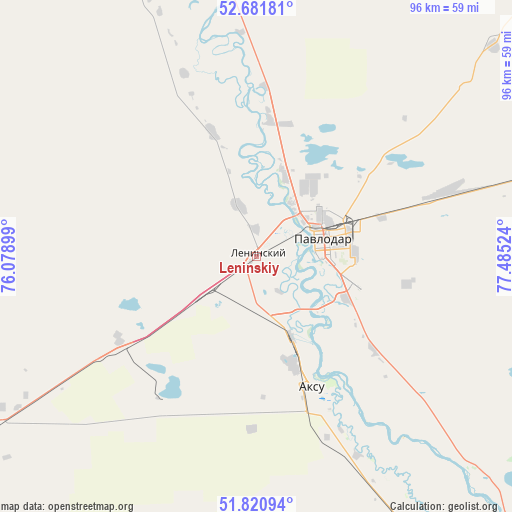
Leninskiy GPS coordinates[2]
52° 15' 12.456" North, 76° 46' 55.596" East
| Map corner | latitude | longitude |
|---|---|---|
| Upper-left | 52.68181°, | 76.07899° |
| Center: | 52.25346°, | 76.78211° |
| Lower-right: | 51.82094°, | 77.48524° |
| Map W x H: | 95.7×95.7 km | = 59.5×59.5mi |
| max Lat: | 54.90596° ⇑15.9% North |
| Leninskiy: | 52.25346° |
| min Lat: | ⇓84.1% South 40.66338° |
| min Long | Leninskiy | max Long |
| 46.83361° | 76.78211° | 84.87144° |
| W 78.1%⇐ | ⇒21.9% E |
Elevation
Elevation of Leninskiy is 109 m = 358 ft, and this is 247.5 m = 812 ft below average elevation for this country.
| Max E: |
1847 m = 6060 ft | 81.9% |
| Avg. | 356.5 m = 1170 ft | |
| Leninskiy | 109 m = 358 ft | |
Min E: |
-26 m = -85 ft | 18.1% |
See also: Kazakhstan elevation on elevation.city.
Geographical zone
Leninskiy is located in North temperate zone (between Tropic of Cancer and the Arctic Circle). Distance of this North polar circle is 1591.1 km =988.7 mi to North.| Distance of | km | miles | from Leninskiy |
|---|---|---|---|
| North Pole | 4197 | 2607.9 | to North |
| Arctic Circle | 1591.1 | 988.7 | to North |
| Tropic Cancer | 3204.1 | 1990.9 | to South |
| Equator | 5810 | 3610.2 | to South |


Nearby cities:
15 places around Leninskiy: (largest is in red/bold)
• Aksu
25.7 km =16 mi,  157°
157°
• Bayanaul
178.8 km =111.1 mi,  204°
204°
• Belogor’ye
93.3 km =58 mi,  149°
149°
• Bestobe
251.7 km =156.4 mi,  276°
276°
• Ekibastuz
116 km =72.1 mi,  239°
239°
• Irtyshsk
149.5 km =92.9 mi,  323°
323°
• Kalkaman
61.4 km =38.2 mi, 237°
• Kurchatov
206.3 km =128.2 mi,  143°
143°
• Mayqayyng
111 km =69 mi,  217°
217°
• Pavlodar
13 km =8.1 mi,  75°
75°
• Prigorodnoye
296.8 km =184.4 mi, 196°
• Qashyr
101.3 km =62.9 mi,  333°
333°
• Semey
315.9 km =196.3 mi,  130°
130°
• Yermentau
261.7 km =162.6 mi,  254°
254°
• Zhelezinka
173.6 km =107.9 mi, 325°
Sources, notices
• [Note1] Compared only with cities in Kazakhstan existing in our database
• [Src1] Map data: © OpenStreetMap contributors (CC-BY-SA)
• [Src2] Other city data from geonames.org with taken over terms of usage.
• [Src3] Geographical zone / Annual Mean Temperature by Robert A. Rohde @ Wikipedia
