Pakkading geodata
Pakkading (Bolikhamsai) is a seat of a second-order administrative division; located in Laos in Asia/Vientiane (GMT+7) time zone. In our database, there are 24 cities with bigger population. Compared to other cities in Laos, 51.9% of cities are located further ↑North; 51.9% of cities are located further →East and 75% of cities have higher elevation than Pakkading. Note1


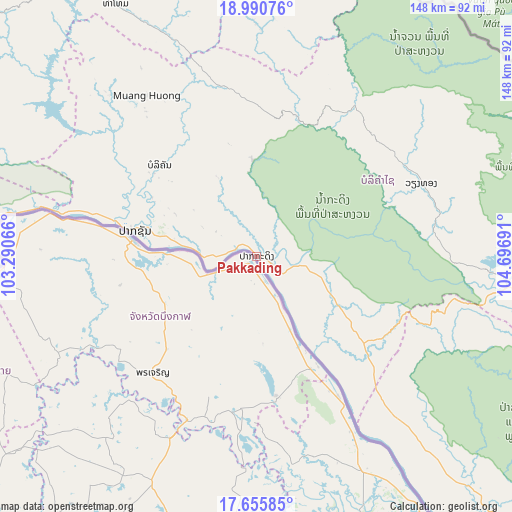
Pakkading GPS coordinates[2]
18° 19' 28.524" North, 103° 59' 37.608" East
| Map corner | latitude | longitude |
|---|---|---|
| Upper-left | 18.99076°, | 103.29066° |
| Center: | 18.32459°, | 103.99378° |
| Lower-right: | 17.65585°, | 104.69691° |
| Map W x H: | 148.4×148.4 km | = 92.2×92.2mi |
| max Lat: | 21.6808° ⇑51.9% North |
| Pakkading: | 18.32459° |
| min Lat: | ⇓48.1% South 14.11785° |
| min Long | Pakkading | max Long |
| 100.4178° | 103.99378° | 107.26667° |
| W 48.1%⇐ | ⇒51.9% E |
Elevation
Elevation of Pakkading is 158 m = 518 ft, and this is 315.6 m = 1035 ft below average elevation for this country.
| Max E: |
1722 m = 5650 ft | 75% |
| Avg. | 473.6 m = 1554 ft | |
| Pakkading | 158 m = 518 ft | |
Min E: |
83 m = 272 ft | 25% |
See also: Laos elevation on elevation.city.
Geographical zone
Pakkading is located in North Torrid zone (between Equator and Tropic of Cancer). Distance of this Northern Tropic circle is 568.4 km =353.2 mi to North.| Distance of | km | miles | from Pakkading |
|---|---|---|---|
| North Pole | 7969.6 | 4952.1 | to North |
| Arctic Circle | 5363.7 | 3332.8 | to North |
| Tropic Cancer | 568.4 | 353.2 | to North |
| Equator | 2037.5 | 1266 | to South |


Nearby cities:
15 places around Pakkading: (largest is in red/bold)
• Ban Nahin
24.9 km =15.5 mi,  111°
111°
• Borikhan
38.7 km =24 mi,  313°
313°
• Huameung
203.3 km =126.3 mi,  356°
356°
• Muang Hinboun
104 km =64.6 mi,  141°
141°
• Muang Kasi
209 km =129.9 mi,  298°
298°
• Muang Khamkeut
78.6 km =48.8 mi,  98°
98°
• Muang Mok
65.1 km =40.5 mi,  1°
1°
• Muang Phôn-Hông
167.6 km =104.1 mi,  276°
276°
• Muang Phônsavan
150.9 km =93.8 mi,  325°
325°
• Pakxan
36 km =22.4 mi, 282°
• Savannakhet
211.4 km =131.4 mi,  157°
157°
• Thakhèk
134.8 km =83.8 mi, 138°
• Vangviang
176 km =109.4 mi,  292°
292°
• Vientiane
152.5 km =94.8 mi,  254°
254°
• Xamtay
188.4 km =117.1 mi,  16°
16°
Sources, notices
• [Note1] Compared only with cities in Laos existing in our database
• [Src1] Map data: © OpenStreetMap contributors (CC-BY-SA)
• [Src2] Other city data from geonames.org with taken over terms of usage.
• [Src3] Geographical zone / Annual Mean Temperature by Robert A. Rohde @ Wikipedia
