Wellawaya geodata
Wellawaya (Uva) is a populated place; located in Sri Lanka in Asia/Colombo (GMT+5.5) time zone. With population of 10,000 people, there are 58 cities with bigger population in this country. Compared to other cities in Sri Lanka, 75% of cities are located further ↑North; 88.2% of cities are located further ←West and 85.5% of cities have lower elevation than Wellawaya. Note1
Administrative division(s):
- Level 1: Uva
- Level 2: Moneragala District
- Level 3: Wellawaya Division
- Level 4: Dimbulamure


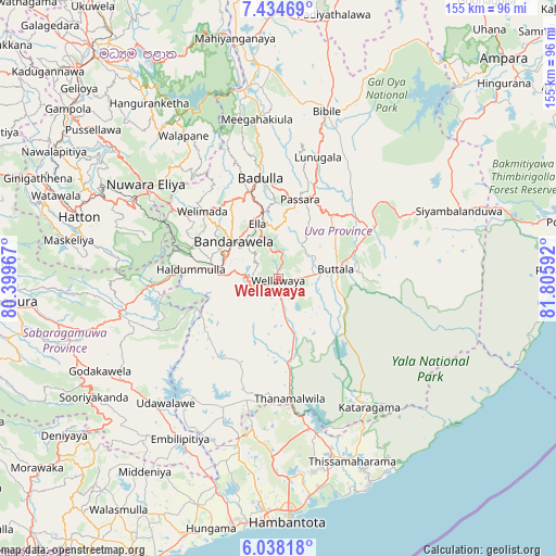
Wellawaya GPS coordinates[2]
6° 44' 12.984" North, 81° 6' 10.044" East
| Map corner | latitude | longitude |
|---|---|---|
| Upper-left | 7.43469°, | 80.39967° |
| Center: | 6.73694°, | 81.10279° |
| Lower-right: | 6.03818°, | 81.80592° |
| Map W x H: | 155.3×155.3 km | = 96.5×96.5mi |
| max Lat: | 9.81667° ⇑75% North |
| Wellawaya: | 6.73694° |
| min Lat: | ⇓25% South 5.92825° |
| min Long | Wellawaya | max Long |
| 79.79528° | 81.10279° | 81.83472° |
| W 88.2%⇐ | ⇒11.8% E |
Elevation
Elevation of Wellawaya is 188 m = 617 ft, and this is 30.6 m = 100 ft above average elevation for this country.
| Max E: |
1868 m = 6129 ft | 14.5% |
| Wellawaya | 188 m 617 ft | |
| Avg. | 157.4 m = 516 ft | |
Min E: |
1 m = 3 ft | 85.5% |
See also: Sri Lanka elevation on elevation.city.
Geographical zone
Wellawaya is located in North Torrid zone (between Equator and Tropic of Cancer). Distance of Equator is 749.1 km =465.5 mi to South.| Distance of | km | miles | from Wellawaya |
|---|---|---|---|
| North Pole | 9258 | 5752.7 | to North |
| Arctic Circle | 6652.1 | 4133.4 | to North |
| Tropic Cancer | 1856.8 | 1153.8 | to North |
| Equator | 749.1 | 465.5 | to South |


Nearby cities:
15 places around Wellawaya: (largest is in red/bold)
• Ampara
89.3 km =55.5 mi,  45°
45°
• Badulla
27.5 km =17.1 mi,  349°
349°
• Ella Town
16.6 km =10.3 mi,  337°
337°
• Gampola
75.6 km =47 mi,  308°
308°
• Haputale
17.1 km =10.6 mi,  280°
280°
• Hatton
58.6 km =36.4 mi,  287°
287°
• Kadugannawa
86 km =53.4 mi, 312°
• Kandy
80.4 km =50 mi,  319°
319°
• Kataragama
44.2 km =27.5 mi,  144°
144°
• Monaragala
31 km =19.3 mi,  61°
61°
• Nuwara Eliya
43.9 km =27.3 mi, 306°
• Ratnapura
77.4 km =48.1 mi,  265°
265°
• Talawakele
53.9 km =33.5 mi, 294°
• Tangalle
86.2 km =53.6 mi,  203°
203°
• Wattegama
42.3 km =26.3 mi,  80°
80°
Sources, notices
• [Note1] Compared only with cities in Sri Lanka existing in our database
• [Src1] Map data: © OpenStreetMap contributors (CC-BY-SA)
• [Src2] Other city data from geonames.org with taken over terms of usage.
• [Src3] Geographical zone / Annual Mean Temperature by Robert A. Rohde @ Wikipedia
