Badulla geodata
Badulla (Uva) is a seat of a first-order administrative division; located in Sri Lanka in Asia/Colombo (GMT+5.5) time zone. With population of 47,587 people, there are 25 cities with bigger population in this country. Compared to other cities in Sri Lanka, 53.9% of cities are located further ↓South; 86.8% of cities are located further ←West and 93.4% of cities have lower elevation than Badulla. Note1


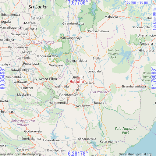
Badulla GPS coordinates[2]
6° 58' 48.72" North, 81° 3' 27.72" East
| Map corner | latitude | longitude |
|---|---|---|
| Upper-left | 7.67758°, | 80.35458° |
| Center: | 6.9802°, | 81.0577° |
| Lower-right: | 6.28178°, | 81.76083° |
| Map W x H: | 155.2×155.2 km | = 96.4×96.4mi |
| max Lat: | 9.81667° ⇑46.1% North |
| Badulla: | 6.9802° |
| min Lat: | ⇓53.9% South 5.92825° |
| min Long | Badulla | max Long |
| 79.79528° | 81.0577° | 81.83472° |
| W 86.8%⇐ | ⇒13.2% E |
Elevation
Elevation of Badulla is 774 m = 2539 ft, and this is 616.6 m = 2023 ft above average elevation for this country.
| Max E: |
1868 m = 6129 ft | 6.6% |
| Badulla | 774 m 2539 ft | |
| Avg. | 157.4 m = 516 ft | |
Min E: |
1 m = 3 ft | 93.4% |
See also: Badulla elevation on elevation.city.
Geographical zone
Badulla is located in North Torrid zone (between Equator and Tropic of Cancer). Distance of Equator is 776.1 km =482.2 mi to South.| Distance of | km | miles | from Badulla |
|---|---|---|---|
| North Pole | 9230.9 | 5735.8 | to North |
| Arctic Circle | 6625 | 4116.6 | to North |
| Tropic Cancer | 1829.8 | 1137 | to North |
| Equator | 776.1 | 482.2 | to South |


Nearby cities:
15 places around Badulla: (largest is in red/bold)
• Ampara
77.4 km =48.1 mi,  62°
62°
• Ella Town
11.7 km =7.3 mi,  186°
186°
• Gampola
57.6 km =35.8 mi,  290°
290°
• Haputale
26.6 km =16.5 mi,  206°
206°
• Hatton
52 km =32.3 mi,  259°
259°
• Kadugannawa
66.3 km =41.2 mi,  297°
297°
• Kandy
58.1 km =36.1 mi,  306°
306°
• Kataragama
70 km =43.5 mi,  154°
154°
• Matale
72.6 km =45.1 mi,  318°
318°
• Monaragala
34.3 km =21.3 mi,  110°
110°
• Nuwara Eliya
30.4 km =18.9 mi,  268°
268°
• Ratnapura
79.3 km =49.3 mi,  245°
245°
• Talawakele
44.4 km =27.6 mi, 263°
• Wattegama
50.9 km =31.6 mi, 113°
• Wellawaya
27.5 km =17.1 mi,  169°
169°
Sources, notices
• [Note1] Compared only with cities in Sri Lanka existing in our database
• [Src1] Map data: © OpenStreetMap contributors (CC-BY-SA)
• [Src2] Other city data from geonames.org with taken over terms of usage.
• [Src3] Geographical zone / Annual Mean Temperature by Robert A. Rohde @ Wikipedia
