Ella Town geodata
Ella Town (Uva) is a populated place; located in Sri Lanka in Asia/Colombo (GMT+5.5) time zone. With population of 5,000 people, there are 65 cities with bigger population in this country. Compared to other cities in Sri Lanka, 64.5% of cities are located further ↑North; 85.5% of cities are located further ←West and 94.7% of cities have lower elevation than Ella Town. Note1
Administrative division(s):
- Level 1: Uva
- Level 2: Badulla District
- Level 3: Ella Division
- Level 4: Ella


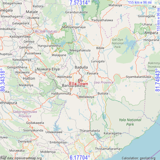
Ella Town GPS coordinates[2]
6° 52' 32.16" North, 81° 2' 46.68" East
| Map corner | latitude | longitude |
|---|---|---|
| Upper-left | 7.57314°, | 80.34318° |
| Center: | 6.8756°, | 81.0463° |
| Lower-right: | 6.17704°, | 81.74943° |
| Map W x H: | 155.2×155.2 km | = 96.4×96.4mi |
| max Lat: | 9.81667° ⇑64.5% North |
| Ella Town: | 6.8756° |
| min Lat: | ⇓35.5% South 5.92825° |
| min Long | Ella Town | max Long |
| 79.79528° | 81.0463° | 81.83472° |
| W 85.5%⇐ | ⇒14.5% E |
Elevation
Elevation of Ella Town is 1031 m = 3383 ft, and this is 873.6 m = 2866 ft above average elevation for this country.
| Max E: |
1868 m = 6129 ft | 5.3% |
| Ella Town | 1031 m 3383 ft | |
| Avg. | 157.4 m = 516 ft | |
Min E: |
1 m = 3 ft | 94.7% |
See also: Sri Lanka elevation on elevation.city.
Geographical zone
Ella Town is located in North Torrid zone (between Equator and Tropic of Cancer). Distance of Equator is 764.5 km =475 mi to South.| Distance of | km | miles | from Ella Town |
|---|---|---|---|
| North Pole | 9242.6 | 5743.1 | to North |
| Arctic Circle | 6636.7 | 4123.9 | to North |
| Tropic Cancer | 1841.4 | 1144.2 | to North |
| Equator | 764.5 | 475 | to South |


Nearby cities:
15 places around Ella Town: (largest is in red/bold)
• Ampara
84.4 km =52.4 mi,  56°
56°
• Badulla
11.7 km =7.3 mi,  6°
6°
• Gampola
61.6 km =38.3 mi,  301°
301°
• Haputale
16.1 km =10 mi,  220°
220°
• Hatton
49.8 km =30.9 mi,  272°
272°
• Kadugannawa
71.4 km =44.4 mi,  306°
306°
• Kandy
64.8 km =40.3 mi,  315°
315°
• Kataragama
60.5 km =37.6 mi,  148°
148°
• Matale
81 km =50.3 mi, 324°
• Monaragala
33.4 km =20.8 mi,  90°
90°
• Nuwara Eliya
30.9 km =19.2 mi,  289°
289°
• Ratnapura
74 km =46 mi,  253°
253°
• Talawakele
43.4 km =27 mi,  279°
279°
• Wattegama
48.7 km =30.3 mi,  100°
100°
• Wellawaya
16.6 km =10.3 mi,  157°
157°
Sources, notices
• [Note1] Compared only with cities in Sri Lanka existing in our database
• [Src1] Map data: © OpenStreetMap contributors (CC-BY-SA)
• [Src2] Other city data from geonames.org with taken over terms of usage.
• [Src3] Geographical zone / Annual Mean Temperature by Robert A. Rohde @ Wikipedia
